Fichier:Mississippi-Coast-towns-NOAA.jpg
Pas de plus haute résolution disponible.
Mississippi-Coast-towns-NOAA.jpg (750 × 382 pixels, taille du fichier : 57 kio, type MIME : image/jpeg)
Ce fichier et sa description proviennent de Wikimedia Commons.

|
Cette image (de type carte) devrait être recréée dans un format vectoriel, en tant que fichier SVG. Cela offrirait plusieurs avantages : voir Commons:Media for cleanup pour plus d'informations. Si une version SVG de cette image est déjà disponible, merci de bien vouloir l'envoyer. Après cela, remplacez ce modèle par {{vector version available|nouveau nom d'image.svg}}.
|


Description
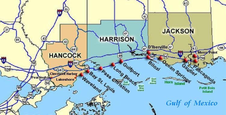
| Description | Coastal map of the U.S. state of Mississippi, showing major towns and cities in the three coastal counties: Hancock, Harrison, and Jackson County. Also shown are Cat Island, West Ship Island, East Ship Island, Horn Island and Petit Bois Island.The locations of towns, roads and offshore islands are based on NOAA and NASA maps. |
| Date | |
| Source |
Travail personnel; self-made (hand-edited with MS-Paint)
Pure stupidity: The map is in quick JPEG format, for large display as highly readable, in about 20 articles that display the map. JPEG clarity is enhanced by painted areas behind many labels, causing the wording to be clearer than even a massive SVG or PNG-format file could provide, due to the sharp display contrast of JPEG files. JPEG Clarity: Even though JPEG images have artifacts, they can display clearer wording in small maps due to auto-contrast enhancement. The same painted/shaded areas, that illuminate wording, would make the map excessively gargantuan in slow cumbersome PNG or SVG format, as is the case with terrain maps, which also should NEVER be converted to massive PNG format. |
| Auteur | Wikid77 |
Conditions d’utilisation
| Cette œuvre a été placée dans le domaine public par son auteur, I, Wikid77. Ceci s’applique dans le monde entier. Dans certains pays, ceci peut ne pas être possible ; dans ce cas : I, Wikid77 accorde à toute personne le droit d’utiliser cette œuvre dans n’importe quel but, sans aucune condition, sauf celles requises par la loi. |
Historique du fichier
Cliquer sur une date et heure pour voir le fichier tel qu'il était à ce moment-là.
| Date et heure | Vignette | Dimensions | Utilisateur | Commentaire | |
|---|---|---|---|---|---|
| actuel | 26 juin 2007 à 04:54 | | 750 × 382 (57 kio) | Wikid77 | Brown-toned map: Hancock County as tan (was green); put "Gulf of Mexico" Antigua font; shift labels on islands |
| 26 juin 2007 à 02:17 |  | 750 × 382 (56 kio) | Wikid77 | Mississippi coastal map, with "Horn Island" relabeled, clarified Hwy "90" and "63" icons. | |
| 21 juin 2007 à 20:56 |  | 750 × 382 (56 kio) | Wikid77 | re-load of image file, in case internal data was garbled | |
| 21 juin 2007 à 20:11 |  | 750 × 382 (56 kio) | Wikid77 | {{Information |Description=Coastal map of the U.S. state of en:Mississippi, showing major towns and cities in the 3 coastal counties: Hancock, Harrison, a |
Utilisation du fichier
Les 6 pages suivantes utilisent ce fichier :
Usage global du fichier
Les autres wikis suivants utilisent ce fichier :
- Utilisation sur ca.wikipedia.org
- Utilisation sur de.wikipedia.org
- Utilisation sur en.wikipedia.org
- Hancock County, Mississippi
- Pearlington, Mississippi
- Waveland, Mississippi
- Biloxi, Mississippi
- Gulfport, Mississippi
- Long Beach, Mississippi
- Gautier, Mississippi
- Ocean Springs, Mississippi
- Pascagoula Abduction
- Effects of Hurricane Katrina in Mississippi
- Ship Island
- Horn Island Chemical Warfare Service Quarantine Station
- Utilisation sur fy.wikipedia.org
- Utilisation sur he.wikipedia.org
- Utilisation sur hu.wikipedia.org
- Utilisation sur it.wikipedia.org
- Utilisation sur ja.wikipedia.org
- Utilisation sur pt.wikipedia.org
- Utilisation sur tr.wikipedia.org
- Utilisation sur vi.wikipedia.org
- Utilisation sur zh.wikipedia.org