Fichier:Maryland Campaign.png
Taille de cet aperçu : 531 × 600 pixels. Autres résolutions : 212 × 240 pixels | 425 × 480 pixels | 680 × 768 pixels | 906 × 1 024 pixels | 1 601 × 1 809 pixels.
Fichier d’origine (1 601 × 1 809 pixels, taille du fichier : 576 kio, type MIME : image/png)
Ce fichier et sa description proviennent de Wikimedia Commons.
Description
| Description |
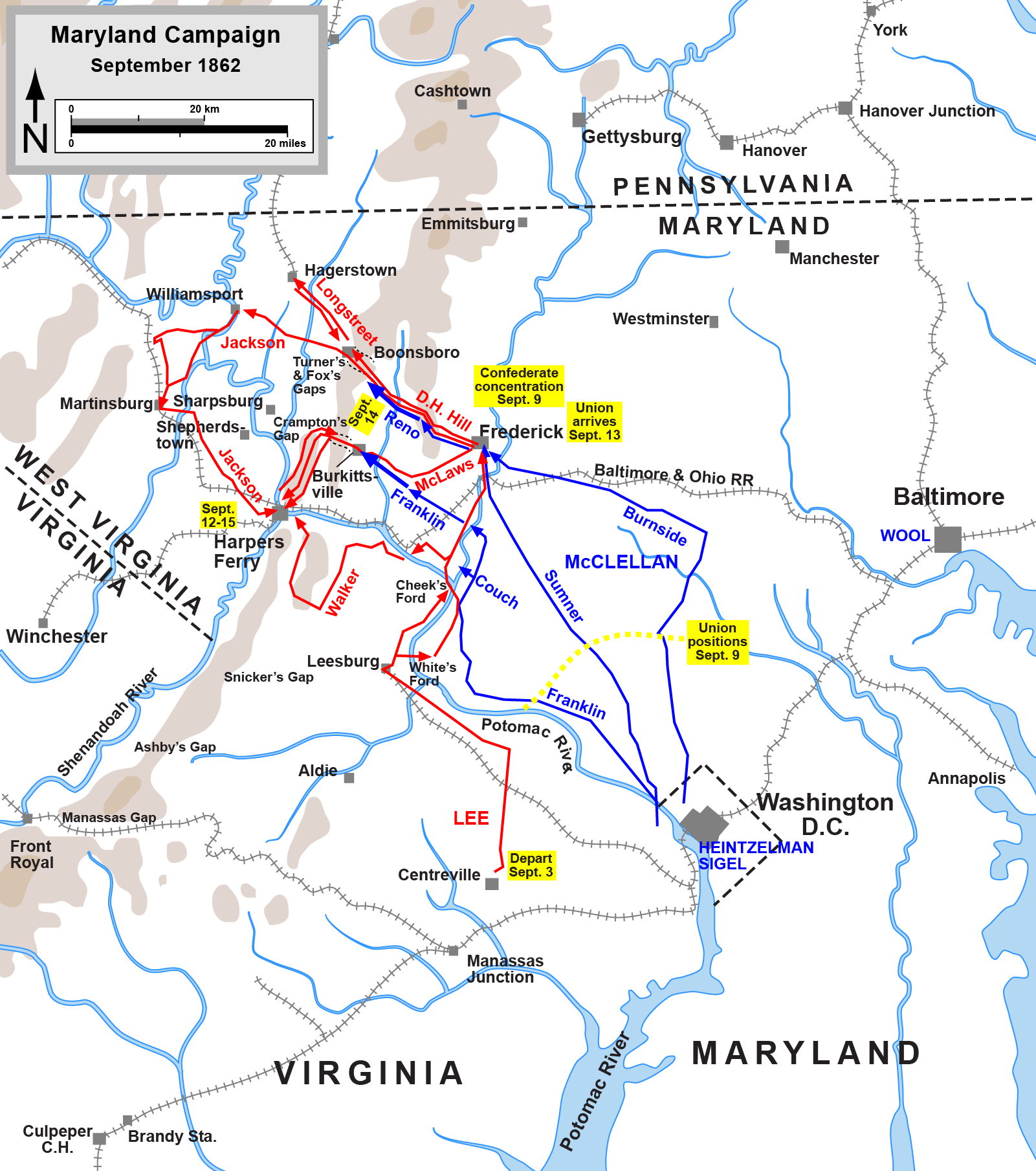
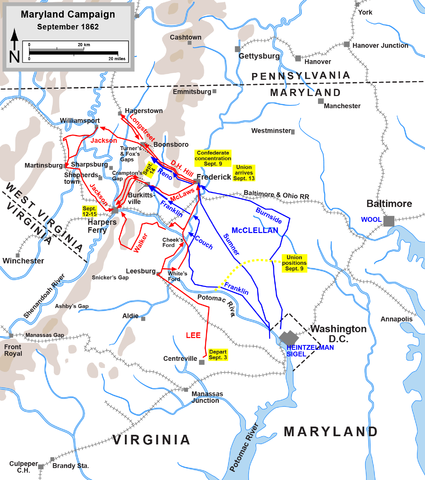
English: Map of the Maryland Campaign of the American Civil War, actions Sept. 3-15. Drawn by Hal Jespersen in Adobe Illustrator CS5. Graphic source file is available at http://www.posix.com/CWmaps/ |
| Date | (first version); 6 mars 2011 (last version) |
| Source | http://www.posix.com/CWmaps/Maryland_Campaign.png |
| Auteur | Hal Jespersen at en.wikipedia |
| PNG information | Cette carte a été créée avec Adobe Illustrator |
Conditions d’utilisation
| Cette œuvre a été placée dans le domaine public par son auteur, Hal Jespersen. Ceci s’applique dans le monde entier. Dans certains pays, ceci peut ne pas être possible ; dans ce cas : Hal Jespersen accorde à toute personne le droit d’utiliser cette œuvre dans n’importe quel but, sans aucune condition, sauf celles requises par la loi.
|

|
Une version vectorielle de cette image existe, dans le format « SVG ». Si elle n’est pas inférieure, elle devrait être utilisée à la place de la présente version pour des affichages en plus grandes dimensions ou nécessitant une meilleure résolution.
File:Maryland Campaign.png → File:Maryland Campaign a.svg
Pour plus d’informations sur les images vectorielles, consultez la page de transition de Commons vers le format SVG. Voir aussi les informations à propos de la manière dont le logiciel MediaWiki gère les images au format SVG. |
 |
Journal des téléversements d’origine
(All user names refer to en.wikipedia)
- 2006-06-17 16:04 Hlj 1502×1700×8 (540349 bytes) Map of the [[Maryland Campaign]] of the [[American Civil War]], actions Sept. 3-15. Drawn by Hal Jespersen in Macromedia Freehand. Graphic source file is available at http://www.posix.com/CWmaps/
Historique du fichier
Cliquer sur une date et heure pour voir le fichier tel qu'il était à ce moment-là.
| Date et heure | Vignette | Dimensions | Utilisateur | Commentaire | |
|---|---|---|---|---|---|
| actuel | 30 mars 2011 à 00:46 | | 1 601 × 1 809 (576 kio) | Hlj | Update to graphical format of rivers and roads. |
| 7 mars 2011 à 01:07 |  | 1 601 × 1 809 (450 kio) | Innotata | New version from enwiki, uploaded by original uploader. Upload summaries: "Fixed DC boundary. Adobe Illustrator source file at http://www.posix.com/CWmaps/"; "minor graphical changes to conform to style used by most ACW maps; added legend and scale." | |
| 26 avril 2007 à 04:09 |  | 1 502 × 1 700 (528 kio) | Qbek | {{Information |Description=Map of the en:Maryland Campaign of the en:American Civil War, actions Sept. 3-15. Drawn by Hal Jespersen in Macromedia Freehand. Graphic source file is available at http://www.posix.com/CWmaps/ |Source=Originally from |
Utilisation du fichier
Les 3 pages suivantes utilisent ce fichier :
Usage global du fichier
Les autres wikis suivants utilisent ce fichier :
- Utilisation sur azb.wikipedia.org
- Utilisation sur cs.wikipedia.org
- Utilisation sur da.wikipedia.org
- Utilisation sur de.wikipedia.org
- Utilisation sur es.wikipedia.org
- Utilisation sur fa.wikipedia.org
- Utilisation sur hu.wikipedia.org
- Utilisation sur it.wikipedia.org
- Utilisation sur ja.wikipedia.org
- Utilisation sur ko.wikipedia.org
- Utilisation sur la.wikipedia.org
- Utilisation sur ms.wikipedia.org
- Utilisation sur nl.wikipedia.org
- Utilisation sur no.wikipedia.org
- Utilisation sur pl.wikipedia.org
- Utilisation sur pt.wikipedia.org
- Utilisation sur ro.wikipedia.org
- Utilisation sur sr.wikipedia.org
- Utilisation sur vi.wikipedia.org
- Utilisation sur zh.wikipedia.org