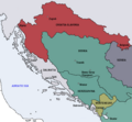
Fichier:Map of the Kingdom of Croatia-Slavonia (1885).png
Map_of_the_Kingdom_of_Croatia-Slavonia_(1885).png (542 × 502 pixels, taille du fichier : 31 kio, type MIME : image/png)
Historique du fichier
Cliquer sur une date et heure pour voir le fichier tel qu'il était à ce moment-là.
| Date et heure | Vignette | Dimensions | Utilisateur | Commentaire | |
|---|---|---|---|---|---|
| actuel | 11 octobre 2009 à 13:11 |  | 542 × 502 (31 kio) | DIREKTOR | {{Information |Description={{en|1=Map of the Kingdom of Croatia Slavonia cca. 1885. The Kingdom was a part of Transleithanian Austria-Hungary, the Kingdom of Hungary (Lands of the Crown of St. Stephen).}} |Source={{own}} |Author=DIREKTOR |
| 11 octobre 2009 à 13:07 |  | 542 × 502 (33 kio) | DIREKTOR | {{Information |Description={{en|1=Map of the Kingdom of Croatia Slavonia cca. 1885. The Kingdom was a part of Transleithanian Austria-Hungary, the Kingdom of Hungary (Lands of the Crown of St. Stephen).}} |Source={{own}} |Author=DIREKTOR | |
| 10 octobre 2009 à 23:31 |  | 542 × 502 (33 kio) | DIREKTOR | {{Information |Description={{en|1=Map of the Kingdom of Croatia Slavonia cca. 1885. The Kingdom was a part of Transleithanian Austria-Hungary, the Kingdom of Hungary (Lands of the Crown of St. Stephen).}} |Source={{own}} |Author=DIREKTOR |
Utilisation du fichier
La page suivante utilise ce fichier :
Usage global du fichier
Les autres wikis suivants utilisent ce fichier :
- Utilisation sur ar.wikipedia.org
- Utilisation sur bs.wikipedia.org
- Utilisation sur en.wikipedia.org
- Utilisation sur ga.wikipedia.org
- Utilisation sur he.wikipedia.org
- Utilisation sur id.wikipedia.org
- Utilisation sur ka.wikipedia.org
- Utilisation sur ko.wikipedia.org
- Utilisation sur ku.wikipedia.org
- Utilisation sur pt.wikipedia.org
- Utilisation sur sk.wikipedia.org
- Utilisation sur sr.wikipedia.org
- Utilisation sur tr.wikipedia.org
- Utilisation sur uk.wikipedia.org
- Utilisation sur www.wikidata.org
