Fichier:Map Cymru 1996 gyda rhifau.svg

Taille de cet aperçu PNG pour ce fichier SVG : 483 × 600 pixels. Autres résolutions : 193 × 240 pixels | 386 × 480 pixels | 618 × 768 pixels | 824 × 1 024 pixels | 1 649 × 2 048 pixels | 500 × 621 pixels.
Fichier d’origine (Fichier SVG, nominalement de 500 × 621 pixels, taille : 50 kio)
Ce fichier et sa description proviennent de Wikimedia Commons.
Description
This version has all the extra SVG-cruft removed, all counties in separate groups, and the "id" field of each group set to the Welsh name of each county rather than a number.
| Description | Same as Image:Map Cymru 1996 heb enwau.svg, but the numbers from Image:WalesNumbered.png have been added back. |
| Source | Image:WalesNumbered.png + GIMP + VectorMagic + Inkscape + emacs |
| Auteur | User:Marnanel, after en:User:Morwen |
| Autorisation (Réutilisation de ce fichier) |
GFDL |
| Autres versions | Image:WalesNumbered.png |
Conditions d’utilisation
| Ce fichier est disponible selon les termes de la licence Creative Commons Attribution – Partage dans les Mêmes Conditions 3.0 (non transposée). Sujet aux avertissements. | ||
| ||
| Ce bandeau de licence a été ajouté à ce fichier dans le cadre de la procédure de mise à jour des licences des images sous GFDL. |

|
Vous avez la permission de copier, distribuer et modifier ce document selon les termes de la GNU Free Documentation License version 1.2 ou toute version ultérieure publiée par la Free Software Foundation, sans sections inaltérables, sans texte de première page de couverture et sans texte de dernière page de couverture. Un exemplaire de la licence est inclus dans la section intitulée GNU Free Documentation License. Sujet aux avertissements. |
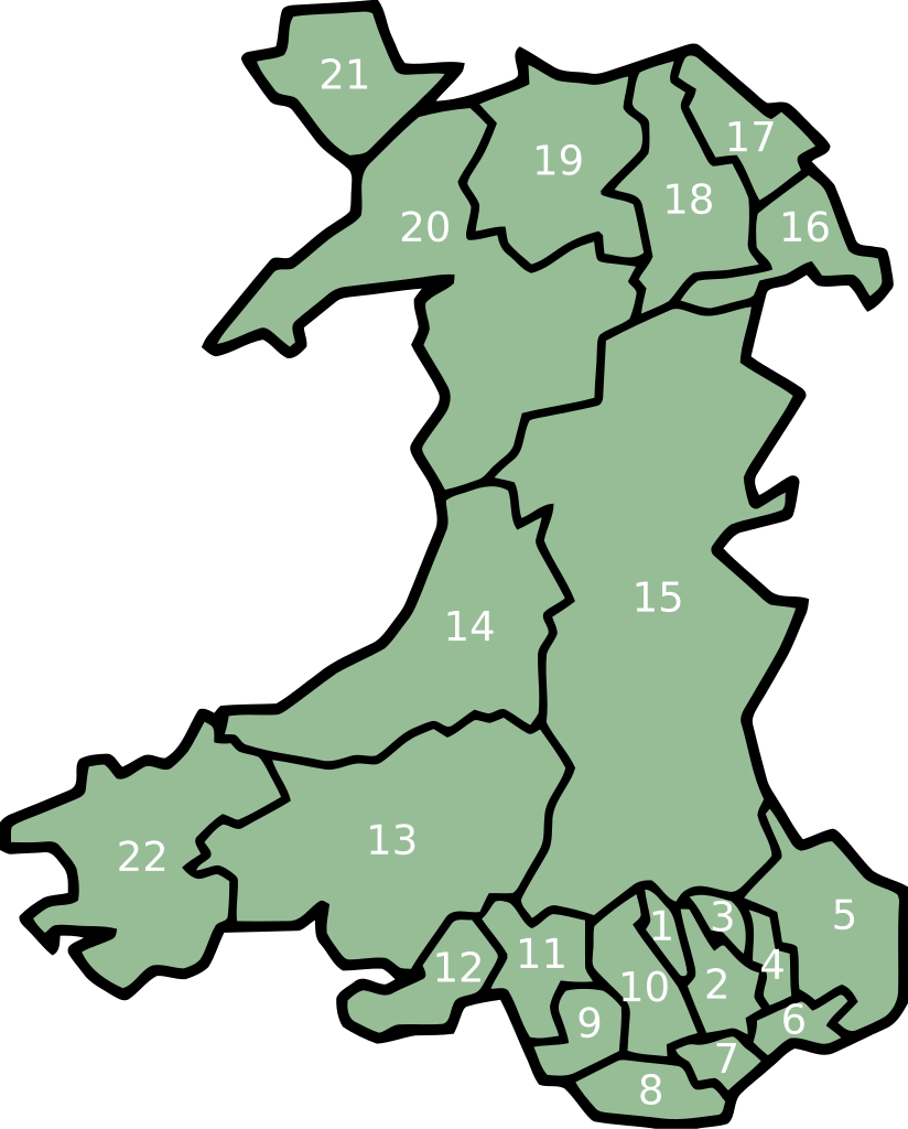
key
- Merthyr Tydfil/Merthyr Tudful
- Caerphilly/Caerffili
- Blaenau Gwent
- Torfaen/Tor-faen
- Monmouthshire/Sir Fynwy
- Newport/Casnewydd
- Cardiff/Caerdydd
- Vale of Glamorgan/Bro Morgannwg
- Bridgend/Pen-y-bont ar Ogwr
- Rhondda Cynon Taff/Rhondda Cynon Tâf
- Neath Port Talbot/Castell-nedd Port Talbot
- Swansea/Abertawe
- Carmarthenshire/Sir Gaerfyrddin
- Ceredigion
- Powys
- Wrexham/Wrecsam
- Flintshire/Sir y Fflint
- Denbighshire/Sir Ddinbych
- Conwy
- Gwynedd
- Isle of Anglesey/Ynys Môn
- Pembrokeshire/Sir Benfro
Historique du fichier
Cliquer sur une date et heure pour voir le fichier tel qu'il était à ce moment-là.
| Date et heure | Vignette | Dimensions | Utilisateur | Commentaire | |
|---|---|---|---|---|---|
| actuel | 12 février 2008 à 04:06 | | 500 × 621 (50 kio) | Marnanel | This version has all the extra SVG-cruft removed, all counties in separate groups, and the "id" field of each group set to the Welsh name of each county rather than a number. {{Information |Description=Same as Image:Map Cymru 1996 heb enwau.svg, but |
Utilisation du fichier
La page suivante utilise ce fichier :
Usage global du fichier
Les autres wikis suivants utilisent ce fichier :
- Utilisation sur br.wikipedia.org
- Utilisation sur el.wikipedia.org
- Utilisation sur en.wikipedia.org
- Utilisation sur eu.wikipedia.org
- Britainia Handia
- Gales
- Cardiff
- Llanfairpwllgwyngyll
- Swansea
- Gwynedd
- Denbighshire
- Ynys Môn
- Carmarthenshire
- Ceredigion
- Newport (Gales)
- Merthyr Tydfil
- Vale of Glamorgan
- Blaenau Gwent
- Torfaen
- Monmouthshire
- Pembrokeshire
- Conwy
- Flintshire
- Wrecsam
- Bridgend
- Rhondda Cynon Taf
- Castell-nedd Port Talbot
- Powys
- Portmeirion
- Blaenau Ffestiniog
- Pwllheli
- Txantiloi:Galesko eskualde aurkibidea
- Galesko azpibanaketak
- Bangor (Gales)
- Cricieth
- Harlech
- Llanbedr
- Aberangell
- Aberdesach
- Aberdyfi
- Abererch
- Abergeirw
- Abergwyngregyn
- Abergynolwyn
- Aberllefenni
- Abersoch
- Abertrinant
- Afon Wen
- Arthog
- Bala (Gales)
Voir davantage sur l’utilisation globale de ce fichier.