Fichier:Irrigation Project along the Orange River.jpg

Taille de cet aperçu : 526 × 599 pixels. Autres résolutions : 211 × 240 pixels | 421 × 480 pixels | 674 × 768 pixels | 898 × 1 024 pixels | 1 797 × 2 048 pixels | 3 159 × 3 600 pixels.
Fichier d’origine (3 159 × 3 600 pixels, taille du fichier : 2,84 Mio, type MIME : image/jpeg)
Ce fichier et sa description proviennent de Wikimedia Commons.
Description
| Description |
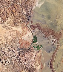
English: Along the banks of this river, roughly 100 kilometres inland from where the river empties into the Atlantic Ocean, irrigation projects take advantage of water from the river and soils from the floodplains to grow produce, turning parts of a normally earth-toned landscape emerald green. A network of bright rectangles of varying shades of green contrasts with surroundings of grey, beige, tan, and rust. Immediately south of a large collection of irrigated plots, faint beige circles reveal centre-pivot irrigation fields apparently allowed to go fallow. |
| Date | |
| Source | NASA Earth Observatory |
| Auteur | Jesse Allen |
Image captured by the Advanced Land Imager (ALI) on NASA’s Earth Observing-1 (EO-1) satellite.
Conditions d’utilisation
| Ce fichier provient de la NASA. Sauf exception, les documents créés par la NASA ne sont pas soumis à copyright. Pour plus d'informations, voir la politique de copyright de la NASA. | ||
 |
Attention :
|
Historique du fichier
Cliquer sur une date et heure pour voir le fichier tel qu'il était à ce moment-là.
| Date et heure | Vignette | Dimensions | Utilisateur | Commentaire | |
|---|---|---|---|---|---|
| actuel | 8 mars 2010 à 15:24 | | 3 159 × 3 600 (2,84 Mio) | Originalwana | {{Information |Description={{en|1=Along the banks of this river, roughly 100 kilometres inland from where the river empties into the Atlantic Ocean, irrigation projects take advantage of water from the river and soils from t |
Utilisation du fichier
La page suivante utilise ce fichier :
Usage global du fichier
Les autres wikis suivants utilisent ce fichier :
- Utilisation sur ca.wikipedia.org
- Utilisation sur en.wikipedia.org
- Utilisation sur fi.wikipedia.org
- Utilisation sur is.wikipedia.org
- Utilisation sur sl.wikipedia.org