Fichier:Irrigation Landsat8.jpg

Fichier d’origine (2 478 × 3 509 pixels, taille du fichier : 4,59 Mio, type MIME : image/jpeg)
Ce fichier et sa description proviennent de Wikimedia Commons.
Description
| Description |
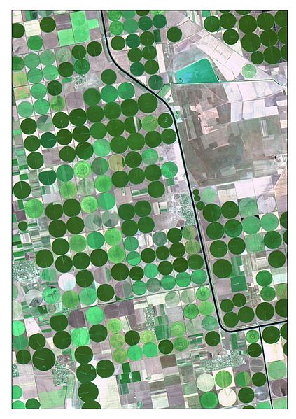
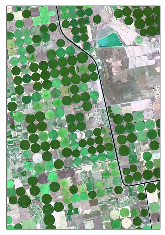
Українська: Супутникове зображення зрошуваних полів та системи іригації Каховсьго зрошувального каналу отримане 7 серпня 2015 року супутником Landsat8 (OLI) у рамках USGS/NASA Landsat Program.
Знімок синтезований у «природних кольорах» (True Color Composite), де кольорам зображення поставлені у відповідність наступні мультиспектральні канали супутникового зображення із видимої частини електромагнітного спектру: R – Red Band (0.64 - 0.67 мкм), G - Green Band (0.53 - 0.59 мкм), B – Blue Band (0.45 - 0.51 мкм). Такий синтез дозволяє вивчати стан агрокультур та їх належне зволоження. Для посилення візуальних характеристик зображення було здійснено підвищення його просторового розрізнення (Pan-Sharpening) та задіяні процедури нелінійного адаптивного і диференціального контрастування. • «Кола на полях» утворюються завдяки яскравим здоровим рослинам у активний період вегетації, які достатньо зрошуються за допомогою дощувальної установки центрального типу. Інтенсивність зеленого кольору залежить від виду сівозміни. • «Годинникова стрілка» - крило такої установки центрального типу. • «Річні кільця», як на деревах, показують непрацюючі сектори установки.English: The picture is satellite image of irrigated crops and Kakhov irrigation canal. It is captured 7-Aug 2015 by Landsat8 (OLI) under USGS/NASA Landsat Program. The image is created as True Color Composite, where R – Red Band (0.64 - 0.67 µm), G – Green Band (0.53 - 0.59 µm) and B – Blue Band (0.45 - 0.51 µm). This band combination is suitable for crop monitoring. For emphasizing characteristics, the image was pan-sharpened by panchromatic band. Nonlinear adaptive procedure of contrasting was applied too. • «Crop circles» appear because of bright plants, which are watered by center pivot irrigation machine. • Lines, looks like “hour hand” are irrigation machine equipment. They are rotate around a pivot and watered with sprinklers. • “Tree rings” are matched with the damaged elements of the irrigation machine. |
| Date | |
| Source | Travail personnel |
| Auteur | Anastasiya.Tishaeva |
| Lieu de la prise de vue | | Voir cet endroit et d’autres images sur : OpenStreetMap |
|---|
Conditions d’utilisation
- Vous êtes libre :
- de partager – de copier, distribuer et transmettre cette œuvre
- d’adapter – de modifier cette œuvre
- Sous les conditions suivantes :
- paternité – Vous devez donner les informations appropriées concernant l'auteur, fournir un lien vers la licence et indiquer si des modifications ont été faites. Vous pouvez faire cela par tout moyen raisonnable, mais en aucune façon suggérant que l’auteur vous soutient ou approuve l’utilisation que vous en faites.
- partage à l’identique – Si vous modifiez, transformez, ou vous basez sur cette œuvre, vous devez distribuer votre contribution sous la même licence ou une licence compatible avec celle de l’original.
| Cette image a été téléversée dans le cadre du Concours de photos scientifiques européen de 2015. |
Historique du fichier
Cliquer sur une date et heure pour voir le fichier tel qu'il était à ce moment-là.
| Date et heure | Vignette | Dimensions | Utilisateur | Commentaire | |
|---|---|---|---|---|---|
| actuel | 28 octobre 2015 à 04:03 | | 2 478 × 3 509 (4,59 Mio) | Anastasiya.Tishaeva | User created page with UploadWizard |
Utilisation du fichier
La page suivante utilise ce fichier :
Usage global du fichier
Les autres wikis suivants utilisent ce fichier :
- Utilisation sur en.wikipedia.org
- Utilisation sur ru.wikipedia.org
- Utilisation sur sl.wikipedia.org
- Utilisation sur uk.wikipedia.org