Fichier:Hungarian autonomous province02.png
Taille de cet aperçu : 619 × 599 pixels. Autres résolutions : 248 × 240 pixels | 496 × 480 pixels | 751 × 727 pixels.
Fichier d’origine (751 × 727 pixels, taille du fichier : 60 kio, type MIME : image/png)
Ce fichier et sa description proviennent de Wikimedia Commons.

|
Cette image (de type carte) devrait être recréée dans un format vectoriel, en tant que fichier SVG. Cela offrirait plusieurs avantages : voir Commons:Media for cleanup pour plus d'informations. Si une version SVG de cette image est déjà disponible, merci de bien vouloir l'envoyer. Après cela, remplacez ce modèle par {{vector version available|nouveau nom d'image.svg}}.
|
Description
| Description |
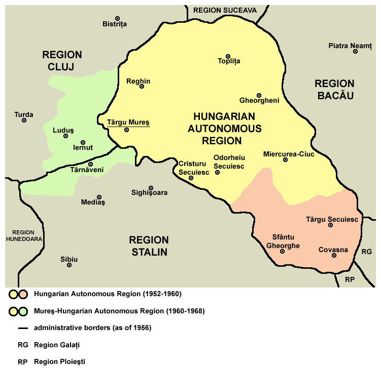
English: Map of the Hungarian Autonomous Region / Magyar Autonomous Region (1952-1960) and Mureş-Hungarian Autonomous Region / Mureş-Magyar Autonomous Region (1960-1968). |
| Date | |
| Source | Transferred from en.wikipedia |
| Auteur | PANONIAN (d · contributions) |
Conditions d’utilisation
| Moi, propriétaire des droits d’auteur sur cette œuvre, la place dans le domaine public. Ceci s'applique dans le monde entier. Dans certains pays, ceci peut ne pas être possible ; dans ce cas : J’accorde à toute personne le droit d’utiliser cette œuvre dans n’importe quel but, sans aucune condition, sauf celles requises par la loi. |

|
This map has been uploaded by Electionworld from en.wikipedia.org to enable the |
References
Primary reference:
Secondary references:
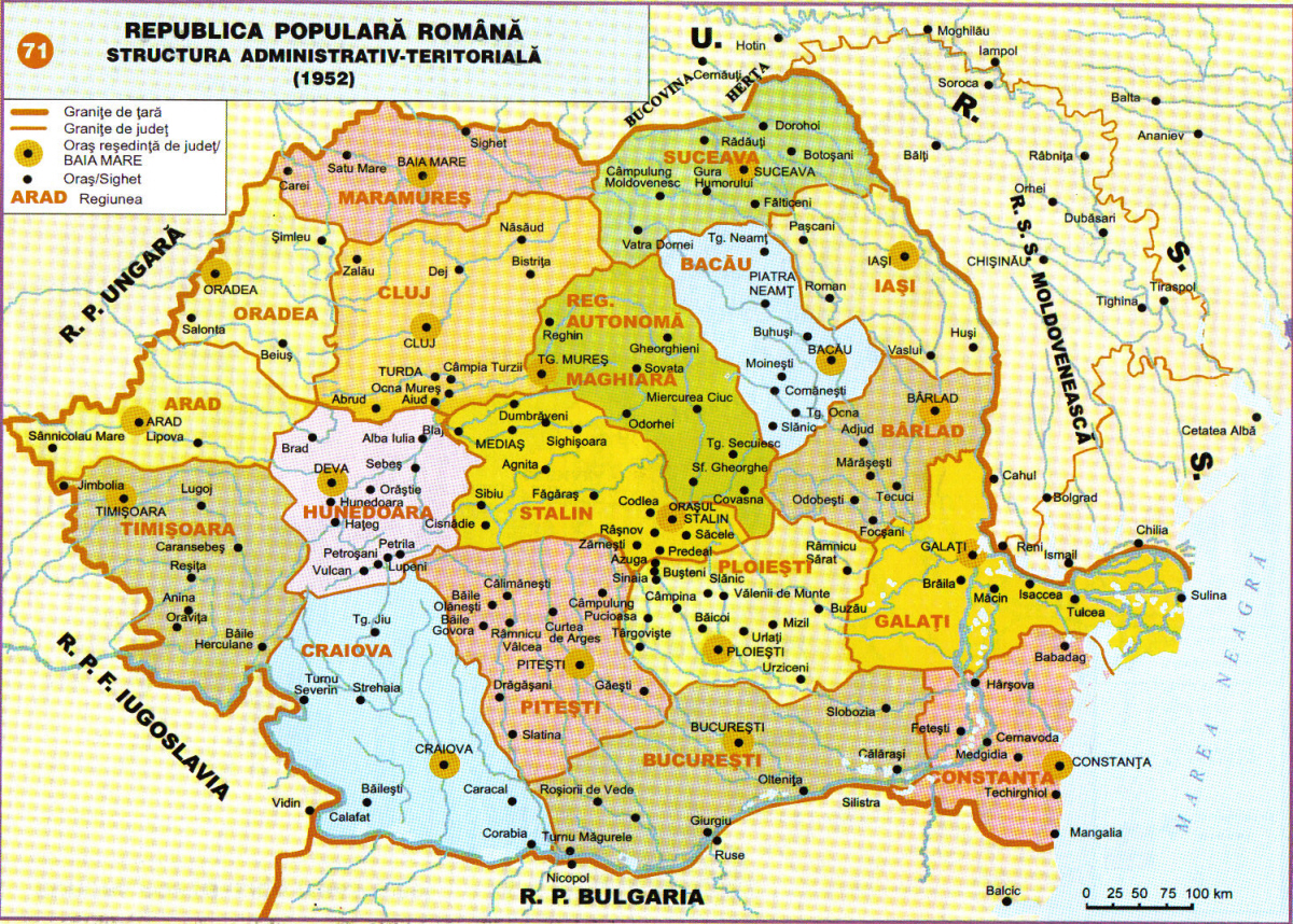
- http://www.adevarul.ro/bbtcontent/clipping/ADVIMA20110612_0443/1.jpg
- http://www.hungarian-human-rights.eu/images/rpr_1952.jpg
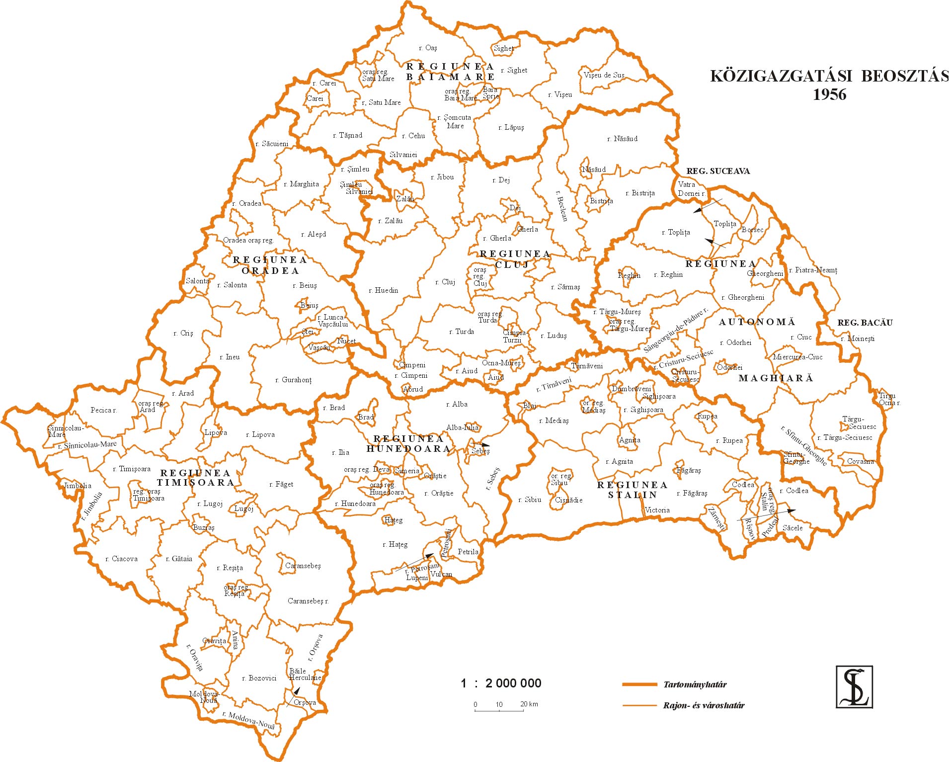
- http://sebok1.adatbank.transindex.ro/kepek/erd1956.jpg
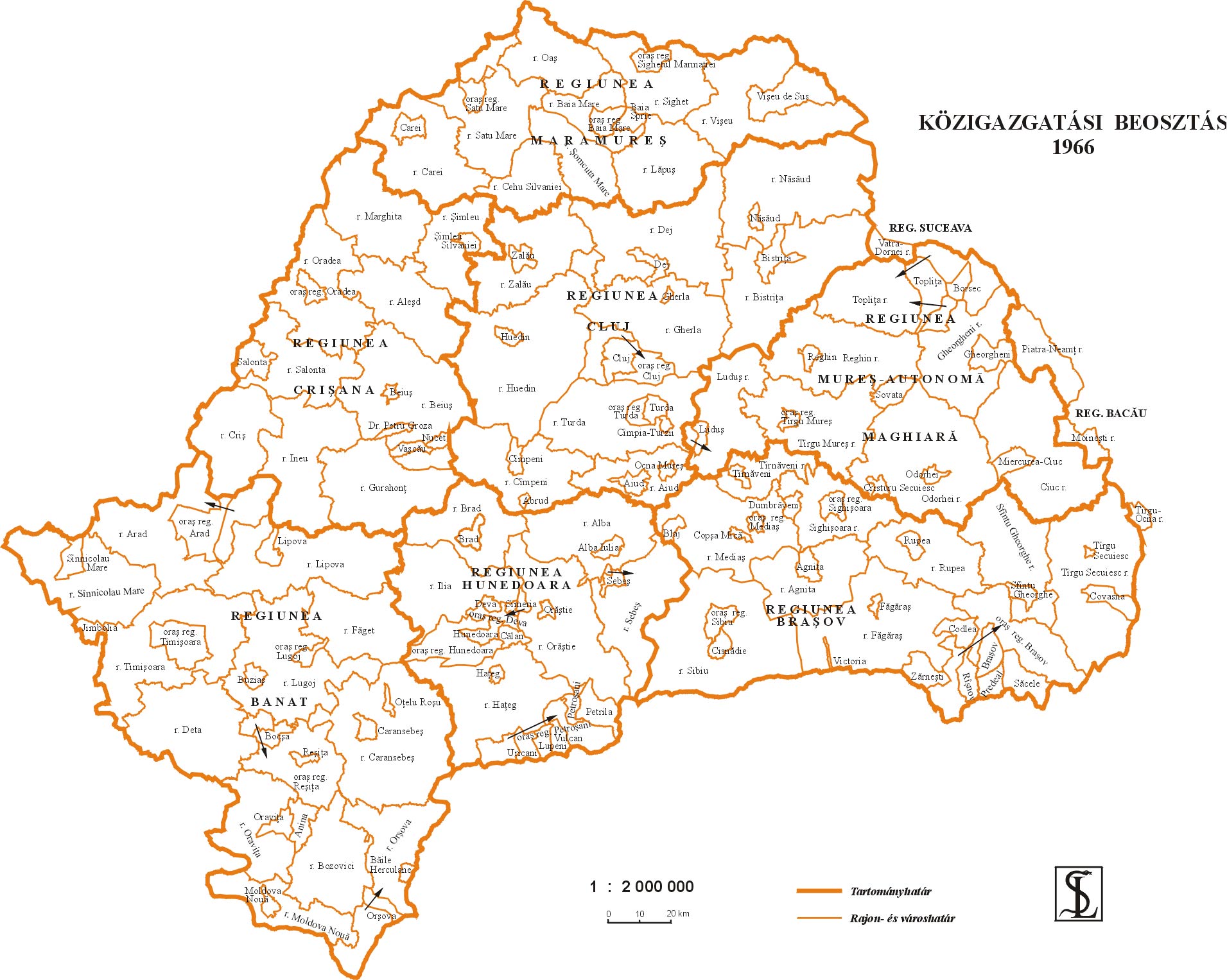
- http://sebok1.adatbank.transindex.ro/kepek/erd1966.jpg
- http://2.bp.blogspot.com/_yYcDY0o6YEA/SXaL1dSAXGI/AAAAAAAAAFk/21nu4zMSKJ8/s600/RO1960-1968.jpg
Historique du fichier
Cliquer sur une date et heure pour voir le fichier tel qu'il était à ce moment-là.
| Date et heure | Vignette | Dimensions | Utilisateur | Commentaire | |
|---|---|---|---|---|---|
| actuel | 26 mars 2013 à 20:59 | | 751 × 727 (60 kio) | PANONIAN | Reverted to version as of 13:05, 24 October 2011 I do not agree with your changes, please upload your file under different name |
| 26 mars 2013 à 11:09 |  | 619 × 599 (103 kio) | Rgvis | Improved version with administrative borders changes shown during the existance of the Soviet-inspired administrative and territorial organisation in Communist Romania (1950-1968). | |
| 24 octobre 2011 à 15:05 |  | 751 × 727 (60 kio) | PANONIAN | improved version | |
| 28 décembre 2006 à 20:56 |  | 716 × 620 (11 kio) | Electionworld | {{ew|en|PANONIAN}} map of the Hungarian Autonomous Province (self made) {{PD-self}} Category:Maps of the history of Romania |
Utilisation du fichier
La page suivante utilise ce fichier :
Usage global du fichier
Les autres wikis suivants utilisent ce fichier :
- Utilisation sur ar.wikipedia.org
- Utilisation sur be.wikipedia.org
- Utilisation sur bg.wikipedia.org
- Utilisation sur ca.wikipedia.org
- Utilisation sur en.wikipedia.org
- Utilisation sur es.wikipedia.org
- Utilisation sur hu.wikipedia.org
- Utilisation sur it.wikipedia.org
- Utilisation sur mk.wikipedia.org
- Utilisation sur nl.wikipedia.org
- Utilisation sur pl.wikipedia.org
- Utilisation sur pt.wikipedia.org
- Utilisation sur ro.wikipedia.org
- Utilisation sur ru.wikipedia.org
- Utilisation sur sl.wikipedia.org
- Utilisation sur sr.wikipedia.org
- Utilisation sur uk.wikipedia.org
- Utilisation sur www.wikidata.org