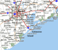
Fichier:Houston Galveston area towns roadmap.gif
Houston_Galveston_area_towns_roadmap.gif (399 × 342 pixels, taille du fichier : 35 kio, type MIME : image/gif)
Historique du fichier
Cliquer sur une date et heure pour voir le fichier tel qu'il était à ce moment-là.
| Date et heure | Vignette | Dimensions | Utilisateur | Commentaire | |
|---|---|---|---|---|---|
| actuel | 24 septembre 2008 à 13:56 |  | 399 × 342 (35 kio) | Wikid77 | +Baytown, +Winnie, Brazoria_N.W.R. |
| 20 septembre 2008 à 19:59 |  | 399 × 342 (35 kio) | Wikid77 | added Port Bolivar, High Island, Sabine Pass; shifted "Galveston Island" darker "Houston" | |
| 13 septembre 2008 à 09:18 |  | 399 × 342 (34 kio) | Wikid77 | initial upload |
Utilisation du fichier
La page suivante utilise ce fichier :
Usage global du fichier
Les autres wikis suivants utilisent ce fichier :
- Utilisation sur de.wikipedia.org
- Utilisation sur en.wikipedia.org
- Utilisation sur id.wikipedia.org
- Utilisation sur ja.wikipedia.org

