Fichier:Hamoun Oasis salt flatlands 2001 satellite.jpg

Taille de cet aperçu : 439 × 600 pixels. Autres résolutions : 176 × 240 pixels | 351 × 480 pixels | 711 × 971 pixels.
Fichier d’origine (711 × 971 pixels, taille du fichier : 120 kio, type MIME : image/jpeg)
Ce fichier et sa description proviennent de Wikimedia Commons.
Description
| Description |
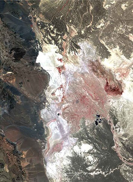
English: In 2001, Hamoun wetlands vanished as Central and South Asia were hitby the largest persistent drought anywhere in the world in period 1999-2001.
The only sign of water in this scorched landscape of extensive salt flats (white) is the Chah Nimeh reservoir in the center right of the image, which is now only used for drinking water. Degraded reed stands in muddy soil are visible as dark red in the southern end of Hamoun-i Puzak. Landsat 7 ETM+ false colour composite created from a combination of the near-infrared, red and green bands (bands 4, 3, and 2) useful for monitoring water and vegetation. |
| Date | |
| Source | http://www.grid.unep.ch/activities/global_change/sistan.php |
| Auteur | United Nations Environment Programme |
Conditions d’utilisation
| Ce fichier provient de la NASA. Sauf exception, les documents créés par la NASA ne sont pas soumis à copyright. Pour plus d'informations, voir la politique de copyright de la NASA. | ||
 |
Attention :
|
Historique du fichier
Cliquer sur une date et heure pour voir le fichier tel qu'il était à ce moment-là.
| Date et heure | Vignette | Dimensions | Utilisateur | Commentaire | |
|---|---|---|---|---|---|
| actuel | 25 septembre 2010 à 06:37 | | 711 × 971 (120 kio) | Aikenware | {{Information |Description={{en|1=In 2001, Hamoun wetlands vanished as Central and South Asia were hitby the largest persistent drought anywhere in the world in period 1999-2001. The only sign of water in this scorched landscape of extensive salt flats ( |
Utilisation du fichier
La page suivante utilise ce fichier :
Usage global du fichier
Les autres wikis suivants utilisent ce fichier :
- Utilisation sur be.wikipedia.org
- Utilisation sur eo.wikipedia.org
- Utilisation sur es.wikipedia.org
- Utilisation sur hi.wikipedia.org
- Utilisation sur lt.wikipedia.org
- Utilisation sur ru.wikipedia.org
- Utilisation sur sv.wikipedia.org
- Utilisation sur ta.wikipedia.org
- Utilisation sur uk.wikipedia.org