Fichier:Gallapagos Islands 1684.jpg
Taille de cet aperçu : 548 × 600 pixels. Autres résolutions : 219 × 240 pixels | 438 × 480 pixels | 701 × 768 pixels | 935 × 1 024 pixels | 1 845 × 2 020 pixels.
Fichier d’origine (1 845 × 2 020 pixels, taille du fichier : 335 kio, type MIME : image/jpeg)
Ce fichier et sa description proviennent de Wikimedia Commons.
Description
| Description |
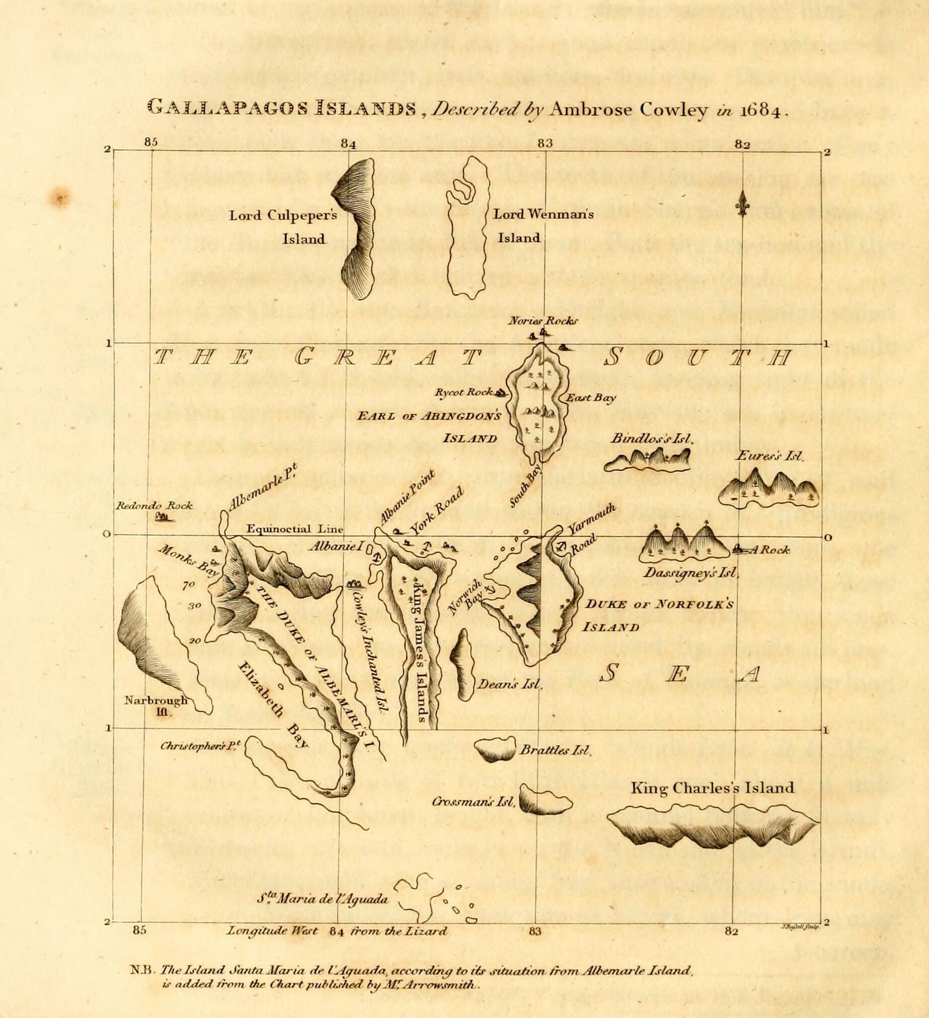
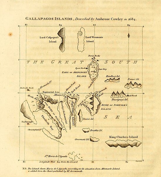
English: Galapagos Islands, described by Ambrose Cowley in 1684.
|
| Date | 1816, revision of a 1684 map |
| Source | James Burney's A Chronological History of the Discoveries in the South Sea or Pacific Ocean, Vol. IV, p. 145. |
| Auteur | John Russell, based on an map by William Ambrosia Cowley with influence from Emanuel Bowen and William Arrowsmith's separate revisions |
Conditions d’utilisation
Ce document est dans le domaine public aux États-Unis. Ceci s'applique aux travaux des États-Unis où le copyright a expiré, souvent parce que sa première publication s'est produite avant le 1er janvier 1929. Voir cette page pour davantage d'explication.
|
 | |
 |
Cette image peut ne pas être dans le domaine public en dehors des États-Unis (ceci s'applique particulièrement au Canada, en Chine (pas Hong Kong, Macao, ni Taïwan), en Allemagne ou en Suisse). Le créateur et l'année de la publication sont l'information essentielle et doivent être fournis.
|
| Annotations | Cette image est annotée : Voir les annotations sur Wikimedia Commons |
Historique du fichier
Cliquer sur une date et heure pour voir le fichier tel qu'il était à ce moment-là.
| Date et heure | Vignette | Dimensions | Utilisateur | Commentaire | |
|---|---|---|---|---|---|
| actuel | 11 mai 2023 à 23:17 | | 1 845 × 2 020 (335 kio) | LlywelynII | Cropped using CropTool to the size of the actual map pasted onto the book page. |
| 11 mai 2023 à 23:13 |  | 2 148 × 2 892 (437 kio) | LlywelynII | Much higher quality version from archive.org copy of the work | |
| 11 mai 2023 à 22:10 |  | 672 × 845 (413 kio) | LlywelynII | Reverted to version as of 18:11, 11 November 2010 (UTC) These are completely different maps from different sources and the original shouldn't've been replaced. | |
| 25 septembre 2012 à 21:12 |  | 2 357 × 3 831 (10,46 Mio) | Jojagal | Mapa de las Islas Galápagos según el Capitán Cowley (1684) - AHG | |
| 11 novembre 2010 à 20:11 |  | 672 × 845 (413 kio) | Alcmaeonid | {{Information |Description={{en|1=Map of the Galapagos Islands as described by Ambrose Cowlev in 1684.}} |Source=A chronological history of the discoveries in the South Sea or Pacific Ocean ; illustrated with charts volume 4 |Author=James Burney |Date=180 |
Utilisation du fichier
La page suivante utilise ce fichier :
Usage global du fichier
Les autres wikis suivants utilisent ce fichier :
- Utilisation sur ast.wikipedia.org
- Utilisation sur de.wikipedia.org
- Utilisation sur en.wikipedia.org
- Utilisation sur es.wikipedia.org
- Utilisation sur fi.wikipedia.org
- Utilisation sur ko.wikipedia.org
- Utilisation sur mk.wikipedia.org
- Utilisation sur pl.wikipedia.org
- Utilisation sur stq.wikipedia.org
- Utilisation sur zh.wikipedia.org