Fichier:Earthquake wave paths.svg

Fichier d’origine (Fichier SVG, nominalement de 300 × 250 pixels, taille : 24 kio)
Ce fichier et sa description proviennent de Wikimedia Commons.
| Cette image a été retouchée, ce qui signifie qu'elle a été modifiée par ordinateur et est différente de l'image d'origine. Liste des modifications : Vectorized. L'image d'origine se trouve ici : Earthquake wave paths.gif:
|
| Description |
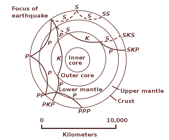
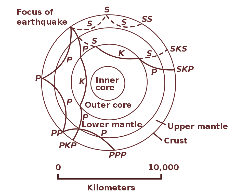
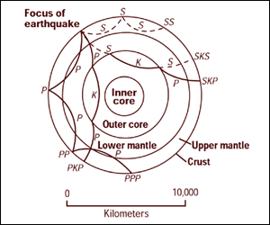
Cross section of the whole Earth, showing the complexity of paths of earthquake waves. The paths curve because the different rock types found at different depths change the speed at which the waves travel. Solid lines marked P are compressional waves; dashed lines marked S are shear waves. S waves do not travel through the core but may be converted to compressional waves (marked K) on entering the core (PKP, SKS). Waves may be reflected at the surface (PP, PPP, SS). Seismographs detect the various types of waves. Analysis of such records reveals structures within the Earth. |
|||
| Source | http://pubs.usgs.gov/gip/interior/fig2.gif ; original upload in english wikipedia, 15 April 2005 by SEWilco | |||
| Auteur | SEWilco | |||
| Autorisation (Réutilisation de ce fichier) |
|
|||
| Autres versions |
Œuvres dérivées de ce fichier : |
Historique du fichier
Cliquer sur une date et heure pour voir le fichier tel qu'il était à ce moment-là.
| Date et heure | Vignette | Dimensions | Utilisateur | Commentaire | |
|---|---|---|---|---|---|
| actuel | 31 octobre 2010 à 04:21 | | 300 × 250 (24 kio) | Hardwigg | {{Information |Description=Cross section of the whole Earth, showing the complexity of paths of earthquake waves. The paths curve because the different rock types found at different depths change the speed at w |
Utilisation du fichier
La page suivante utilise ce fichier :
Usage global du fichier
Les autres wikis suivants utilisent ce fichier :
- Utilisation sur ast.wikipedia.org
- Utilisation sur beta.wikiversity.org
- Utilisation sur bg.wikipedia.org
- Utilisation sur bh.wikipedia.org
- Utilisation sur bn.wikipedia.org
- Utilisation sur ca.wikipedia.org
- Utilisation sur da.wikipedia.org
- Utilisation sur el.wikipedia.org
- Utilisation sur en.wikipedia.org
- Utilisation sur en.wikibooks.org
- Utilisation sur en.wikiquote.org
- Utilisation sur en.wikiversity.org
- Utilisation sur eo.wikipedia.org
- Utilisation sur es.wikipedia.org
- Utilisation sur gl.wikipedia.org
- Utilisation sur hu.wikipedia.org
- Utilisation sur it.wikipedia.org
- Utilisation sur ja.wikipedia.org
- Utilisation sur ko.wikipedia.org
- Utilisation sur mk.wikipedia.org
- Utilisation sur ml.wikipedia.org
- Utilisation sur ms.wikipedia.org
- Utilisation sur nl.wikipedia.org
- Utilisation sur pl.wikipedia.org
- Utilisation sur pt.wikipedia.org
- Utilisation sur sl.wikipedia.org
- Utilisation sur sr.wikipedia.org
- Utilisation sur sv.wikipedia.org
- Utilisation sur th.wikipedia.org
Voir davantage sur l’utilisation globale de ce fichier.