Fichier:EF1 damage Richardson, Texas.jpg

Taille de cet aperçu : 800 × 534 pixels. Autres résolutions : 320 × 213 pixels | 640 × 427 pixels | 964 × 643 pixels.
Fichier d’origine (964 × 643 pixels, taille du fichier : 574 kio, type MIME : image/jpeg)
Ce fichier et sa description proviennent de Wikimedia Commons.
Description
| Description |
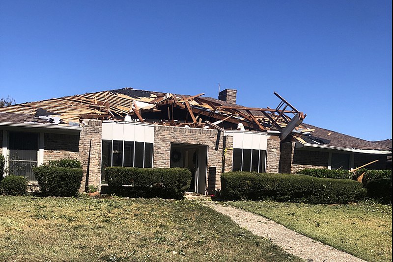
English: Example of EF1 tornado damage. This house in Richardson, Texas lost a large section of its roof surface to a tornado. The image has been cropped to focus on the damaged house. |
| Date | |
| Source | https://services.dat.noaa.gov/arcgis/rest/services/nws_damageassessmenttoolkit/DamageViewer/MapServer/0/1987364/attachments/1238623 |
| Auteur | National Weather Service Forecast Office in Dallas/Fort Worth, Texas |
Conditions d’utilisation
This image is in the public domain because it was stored on the web servers of the U.S. National Oceanic and Atmospheric Administration, specifically on the Damage Assessment Toolkit (DAT), an interactive map and database. Images on the Damage Assessment Toolkit are taken by the 122 National Weather Service forecast offices as well as the National Severe Storms Laboratory.
Thus, all images on the Damage Assessment Toolkit are public domain.
|
Historique du fichier
Cliquer sur une date et heure pour voir le fichier tel qu'il était à ce moment-là.
| Date et heure | Vignette | Dimensions | Utilisateur | Commentaire | |
|---|---|---|---|---|---|
| actuel | 3 décembre 2019 à 04:46 | | 964 × 643 (574 kio) | TornadoLGS | User created page with UploadWizard |
Utilisation du fichier
La page suivante utilise ce fichier :
Usage global du fichier
Les autres wikis suivants utilisent ce fichier :
- Utilisation sur en.wikipedia.org
- Utilisation sur pl.wikipedia.org
- Utilisation sur simple.wikipedia.org
- Utilisation sur th.wikipedia.org