Fichier:ECHO Southern Africa Editable A3 Landscape.png

Taille de cet aperçu : 800 × 600 pixels. Autres résolutions : 320 × 240 pixels | 640 × 480 pixels | 1 024 × 768 pixels | 1 344 × 1 008 pixels.
Fichier d’origine (1 344 × 1 008 pixels, taille du fichier : 353 kio, type MIME : image/png)
Ce fichier et sa description proviennent de Wikimedia Commons.
Description
| Description |
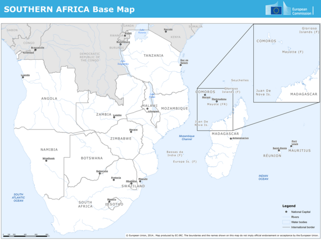
English: Base map of Southern Africa including Angola, Namibia, Botswana, South Africa, Lesotho, Swaziland, Zimbabwe, Mozambique, Zambia, Malawi, Tanzania, Madagascar, Reunion, Mauritius, Mayote, Comoros, Glorioso Islands and Juan De Nova Island. |
| Date | 1er juillet 2014 (date de téléversement) |
| Source | Southern Africa Base Map |
| Auteur | ERCC - Emergency Response Coordination Centre |
| Autres versions |
|
Conditions d’utilisation
Public documents (any content whatever its medium) produced by the Commission or by entities on its behalf published by the Commission or the Publications Office or which have not been published for economic or other practical reasons, such as studies, reports and other data shall be made available for reuse unless otherwise specified[1] without restrictions according to 2011/833/EU: Commission Decision of 12 December 2011 on the reuse of Commission documents
Note: Content on ec.europa.eu or its data portal is published with the specified restrictions of the CC BY 4.0 license.
| |
Ce fichier est disponible selon les termes de la licence Creative Commons Attribution 4.0 International.
- Vous êtes libre :
- de partager – de copier, distribuer et transmettre cette œuvre
- d’adapter – de modifier cette œuvre
- Sous les conditions suivantes :
- paternité – Vous devez donner les informations appropriées concernant l'auteur, fournir un lien vers la licence et indiquer si des modifications ont été faites. Vous pouvez faire cela par tout moyen raisonnable, mais en aucune façon suggérant que l’auteur vous soutient ou approuve l’utilisation que vous en faites.
Historique du fichier
Cliquer sur une date et heure pour voir le fichier tel qu'il était à ce moment-là.
| Date et heure | Vignette | Dimensions | Utilisateur | Commentaire | |
|---|---|---|---|---|---|
| actuel | 4 novembre 2023 à 15:25 | | 1 344 × 1 008 (353 kio) | OptimusPrimeBot | #Spacemedia - Upload of https://erccportal.jrc.ec.europa.eu/API/ERCC/Maps/DownloadPublicMap?contentItemID=727&fileN=SecondFile&forceDownload=True via Commons:Spacemedia |
Utilisation du fichier
Les 4 pages suivantes utilisent ce fichier :