Fichier:Context view, showing the Relift Station, Ditch Rider's House, and Mohawk Mountains in the background. View to south - Wellton-Mohawk Irrigation System, Relift Station, Texas Hill Canal HAER AZ-68-D-1.tif

Taille de cet aperçu JPG pour ce fichier TIF : 756 × 599 pixels. Autres résolutions : 303 × 240 pixels | 605 × 480 pixels | 969 × 768 pixels | 1 280 × 1 015 pixels | 2 560 × 2 030 pixels | 5 362 × 4 252 pixels.
Fichier d’origine (5 362 × 4 252 pixels, taille du fichier : 21,75 Mio, type MIME : image/tiff)
Ce fichier et sa description proviennent de Wikimedia Commons.
Description
| Photographe |
De Vries, David G. |
|||
| Titre |
Context view, showing the Relift Station, Ditch Rider's House, and Mohawk Mountains in the background. View to south - Wellton-Mohawk Irrigation System, Relift Station, Texas Hill Canal 2.5, Northern Terminus of Avenue 51 East, approximately .5 mile south of Union Pacific Railroad, Wellton, Yuma County, AZ |
|||
| Lieu représenté | Arizona; Yuma County; Wellton | |||
| Date | 2005 | |||
| Dimensions | 4 x 5 in. | |||
| Lieu actuel |
Library of Congress Prints and Photographs Division Washington, D.C. 20540 USA http://hdl.loc.gov/loc.pnp/pp.print |
|||
| Numéro d’inventaire |
HAER AZ-68-D-1 |
|||
| Attribution de l’acquisition |
|
|||
| Notes |
|
|||
| Source | https://www.loc.gov/pictures/item/az0535.photos.363745p | |||
| Autorisation (Réutilisation de ce fichier) |
|

| Position de l'objet | | Voir cet endroit et d’autres images sur : OpenStreetMap |
|---|
Historique du fichier
Cliquer sur une date et heure pour voir le fichier tel qu'il était à ce moment-là.
| Date et heure | Vignette | Dimensions | Utilisateur | Commentaire | |
|---|---|---|---|---|---|
| actuel | 2 juillet 2014 à 01:54 | 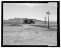 | 5 362 × 4 252 (21,75 Mio) | Fæ | GWToolset: Creating mediafile for Fæ. HABS 1 July 2014 (201:300) |
Utilisation du fichier
La page suivante utilise ce fichier :
Usage global du fichier
Les autres wikis suivants utilisent ce fichier :
- Utilisation sur en.wikipedia.org