Fichier:Contact Period lowland Guatemala.gif
Taille de cet aperçu : 787 × 600 pixels. Autres résolutions : 315 × 240 pixels | 630 × 480 pixels | 828 × 631 pixels.
Fichier d’origine (828 × 631 pixels, taille du fichier : 224 kio, type MIME : image/gif)
Ce fichier et sa description proviennent de Wikimedia Commons.
Description
| Description |
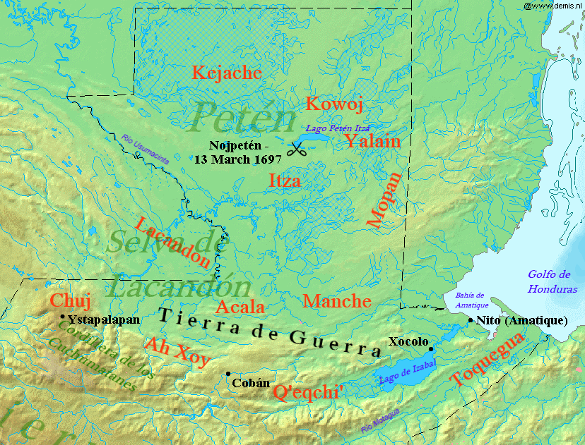
English: Map of Contact Period lowland Guatemala, 16-17th century.
Español: Mapa de las tierras bajas del norte de Guatemala durante el periodo de contacto, siglos XVI-XVII. |
| Date | |
| Source |
Travail personnel avec:
|
| Auteur |
|
| Cette image a été retouchée, ce qui signifie qu'elle a été modifiée par ordinateur et est différente de l'image d'origine. Liste des modifications : Added indigenous territories and geographical locations. L'image d'origine se trouve ici : Map of Guatemala Demis.png:
|
Conditions d’utilisation
Moi, en tant que détenteur des droits d’auteur sur cette œuvre, je la publie sous la licence suivante :
Ce fichier est disponible selon les termes de la licence Creative Commons Attribution – Partage dans les Mêmes Conditions 3.0 (non transposée).
- Vous êtes libre :
- de partager – de copier, distribuer et transmettre cette œuvre
- d’adapter – de modifier cette œuvre
- Sous les conditions suivantes :
- paternité – Vous devez donner les informations appropriées concernant l'auteur, fournir un lien vers la licence et indiquer si des modifications ont été faites. Vous pouvez faire cela par tout moyen raisonnable, mais en aucune façon suggérant que l’auteur vous soutient ou approuve l’utilisation que vous en faites.
- partage à l’identique – Si vous modifiez, transformez, ou vous basez sur cette œuvre, vous devez distribuer votre contribution sous la même licence ou une licence compatible avec celle de l’original.
Historique du fichier
Cliquer sur une date et heure pour voir le fichier tel qu'il était à ce moment-là.
| Date et heure | Vignette | Dimensions | Utilisateur | Commentaire | |
|---|---|---|---|---|---|
| actuel | 15 octobre 2013 à 19:54 | | 828 × 631 (224 kio) | Simon Burchell | +Ah Xoy text |
| 31 janvier 2012 à 22:48 |  | 828 × 631 (227 kio) | Simon Burchell | +Acala text | |
| 30 janvier 2012 à 02:00 |  | 828 × 631 (226 kio) | Simon Burchell | + Q'eqchi' text | |
| 20 janvier 2012 à 01:52 |  | 828 × 631 (226 kio) | Simon Burchell | {{Information |Description={{en|1=Map of Contact Period lowland Guatemala, 16-17th century.}} {{es|1=Mapa de las tierras bajas del norte de Guatemala durante el periodo de contacto, siglos XVI-XVII.}} |Source={{own}} |Date=2012-01-19 |Author= [[User:Simon |
Utilisation du fichier
La page suivante utilise ce fichier :
Usage global du fichier
Les autres wikis suivants utilisent ce fichier :
- Utilisation sur ar.wikipedia.org
- Utilisation sur en.wikipedia.org
- Utilisation sur id.wikipedia.org
- Utilisation sur it.wikipedia.org
- Utilisation sur ja.wikipedia.org
- Utilisation sur pl.wiktionary.org
- Utilisation sur pt.wikipedia.org