Fichier:Chesterfield, St Mary & All Saints' church.jpg

Fichier d’origine (3 347 × 2 533 pixels, taille du fichier : 4,51 Mio, type MIME : image/jpeg)
Ce fichier et sa description proviennent de Wikimedia Commons.
Description
| Description |
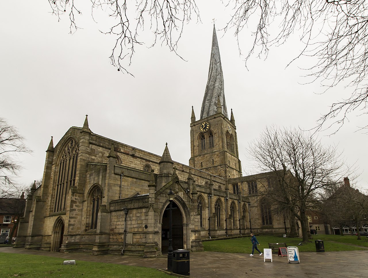
English: Photo by Jenny.
The church mostly dates from the fourteenth century, and is famous for its twisted and leaning spire. It is the largest church in Derbyshire and consists of a nave and clerestory with north and south aisles, north and south transepts, and chancel which is surrounded by four Guild chapels. There is a crossing tower with a 228 foot high spire consisting of timber, clad with herringbone lead plates. The spire, which was added in the mid-fourteenth century, is twisted due to warping, partly from the use of unseasoned timber in its construction, and also the later addition of some 30 tons of lead plating (the original covering was wooden shingles). The twisting was caused by the action of the sun on the lead causing uneven heating and expansion combined with the weight of the lead plating. The nave is of six bays and has a western gallery from the nineteenth century restoration. There is also a Norman font, and a Jacobean pulpit. The chancel is flanked by Guild chapels, two on each side. The north transept was rebuilt in 1769, and George Gilbert Scott carried out restorations in 1843. In 1861 the spire was struck by lightning and beams in the tower smouldered for several hours. At the end of the nineteenth century there was further restoration by Temple Lushington Moore, who designed the main reredos. There was a serious fire in December 1961 which destroyed many of the interior fittings, as well as the Snetzler organ. Some pipes were salvaged and used in the current organ, which is a four manual by Willis. The church contains several monuments to the Foljambe family, from the sixteenth and early seventeenth century. There are several stained-glass windows, from Victorian to modern. |
| Date | |
| Source | https://www.flickr.com/photos/78914786@N06/49514654638/ |
| Auteur | Jules & Jenny |
Ceci est une image d'un bâtiment classé (Angleterre et Pays de Galles) portant le numéro 1334708. |
| Lieu de la prise de vue | | Voir cet endroit et d’autres images sur : OpenStreetMap |
|---|
Conditions d’utilisation
- Vous êtes libre :
- de partager – de copier, distribuer et transmettre cette œuvre
- d’adapter – de modifier cette œuvre
- Sous les conditions suivantes :
- paternité – Vous devez donner les informations appropriées concernant l'auteur, fournir un lien vers la licence et indiquer si des modifications ont été faites. Vous pouvez faire cela par tout moyen raisonnable, mais en aucune façon suggérant que l’auteur vous soutient ou approuve l’utilisation que vous en faites.
| Cette image a été originellement postée sur Flickr par Jules & Jenny à l'adresse https://flickr.com/photos/78914786@N06/49514654638. Elle a été passée en revue le 8 avril 2020 par le robot FlickreviewR 2, qui a confirmé qu'elle se trouvait sous licence cc-by-2.0. |
Historique du fichier
Cliquer sur une date et heure pour voir le fichier tel qu'il était à ce moment-là.
| Date et heure | Vignette | Dimensions | Utilisateur | Commentaire | |
|---|---|---|---|---|---|
| actuel | 8 avril 2020 à 22:58 | | 3 347 × 2 533 (4,51 Mio) | Tm | Uploaded a work by Jules & Jenny from https://www.flickr.com/photos/78914786@N06/49514654638/ with UploadWizard |
Utilisation du fichier
La page suivante utilise ce fichier :
Usage global du fichier
Les autres wikis suivants utilisent ce fichier :
- Utilisation sur en.wikipedia.org