Fichier:Central europe 1572.png
Taille de cet aperçu : 628 × 599 pixels. Autres résolutions : 251 × 240 pixels | 503 × 480 pixels | 922 × 880 pixels.
Fichier d’origine (922 × 880 pixels, taille du fichier : 120 kio, type MIME : image/png)
Ce fichier et sa description proviennent de Wikimedia Commons.
Description
| Description |
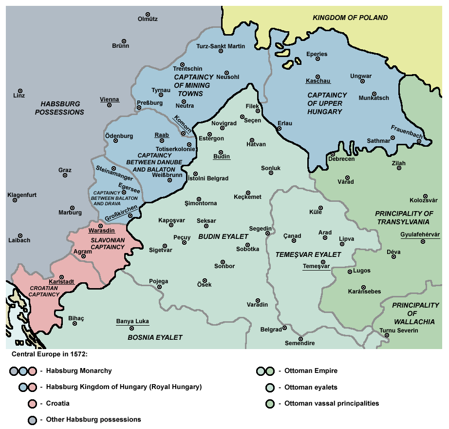
English: Map of Central Europe in 1572: Habsburg Kingdom of Hungary (Royal Hungary), Habsburg Croatia, Ottoman Budin Eyalet, Ottoman Temeşvar Eyalet. |
| Date | |
| Source | Travail personnel |
| Auteur | PANONIAN |
| Autres versions |
|

Conditions d’utilisation
Moi, en tant que détenteur des droits d’auteur sur cette œuvre, je la publie sous la licence suivante :
| Ce fichier est disponible selon les termes de la licence Creative Commons CC0 Don universel au domaine public. | |
| La personne qui a associé une œuvre avec cet acte l’a placée dans le domaine public en renonçant mondialement à tous ses droits sur cette œuvre en vertu des lois relatives au droit d’auteur, ainsi qu’à tous les droits juridiques connexes et voisins qu’elle possédait sur l’œuvre, sans autre limite que celles imposées par la loi. Vous pouvez copier, modifier, distribuer et utiliser cette œuvre, y compris à des fins commerciales, sans qu’il soit nécessaire d’en demander la permission.
|
References
- http://www.sulinet.hu/eletmod/hogyantovabb/tovabbtanulas/elokeszito/tortenelem/6het/map.jpg
- http://honismeret.uw.hu/pictures/history/oszman_torok_birodalom_big.jpg copie d'archive at the Wayback Machine
- http://www.kepido.oszk.hu/attachments/images/nagy/pe94122.jpg
- http://mek.niif.hu/01800/01885/html/cd5m/kepek/nyelvtortenet/ny251pe94122.jpg
- http://mek.oszk.hu/01800/01885/html/cd5m/kepek/c4341pe94122.jpg
- http://mek.oszk.hu/01800/01885/html/cd5m/kepek/tortenelem/to321pe94123b.jpg
- http://hu.wikipedia.org/wiki/Fájl:Torokvilag.jpg[lien mort]
- http://www.sulinet.hu/oroksegtar/data/telepulesek_ertekei/Erd/pages/images/221.jpg
- http://xxlworld.xx.ohost.de/povijest/slike/mape/1606.jpg
- http://www.hic.hr/books/pavlicev/images/s05.gif copie d'archive at the Wayback Machine
- The Times History of Europe, Times Books, London, 2002.
- Peter Rokai - Zoltan Đere - Tibor Pal - Aleksandar Kasaš, Istorija Mađara, Beograd, 2002.
- Dr Dušan J. Popović, Srbi u Vojvodini, knjiga 1, Novi Sad, 1990.
- Dr D. J. Popović, Vojvodina u tursko doba, Zbornik "Vojvodina", knjiga I, Fototipsko izdanje, PROMETEJ, Novi Sad, 2008.
- Halil Inaldžik, Osmansko carstvo, Beograd, 2003.
Historique du fichier
Cliquer sur une date et heure pour voir le fichier tel qu'il était à ce moment-là.
| Date et heure | Vignette | Dimensions | Utilisateur | Commentaire | |
|---|---|---|---|---|---|
| actuel | 5 septembre 2011 à 12:36 | | 922 × 880 (120 kio) | PANONIAN | {{Information |Description ={{en|1=Map of Central Europe in 1572: Habsburg Kingdom of Hungary (Royal Hungary), Habsburg Croatia, Ottoman Budin Eyalet, Ottoman Temeşvar Eyalet. }} |Source ={{own}} |Author =PANONIAN |Da |
Utilisation du fichier
Les 10 pages suivantes utilisent ce fichier :
Usage global du fichier
Les autres wikis suivants utilisent ce fichier :
- Utilisation sur ar.wikipedia.org
- Utilisation sur be.wikipedia.org
- Utilisation sur bg.wikipedia.org
- Utilisation sur bs.wikipedia.org
- Utilisation sur cs.wikipedia.org
- Utilisation sur de.wikipedia.org
- Utilisation sur el.wikipedia.org
- Utilisation sur en.wikipedia.org
- Burgenland
- List of administrative divisions of the Kingdom of Hungary
- Kingdom of Hungary (1526–1867)
- Upper Hungary
- Talk:Upper Hungary
- Ottoman Hungary
- Budin Eyalet
- Captaincies of the Kingdom of Hungary
- Eparchy of Marča
- Transformation of the Ottoman Empire
- User:Falcaorib
- Palanka (fortification)
- Wikipedia:Graphics Lab/Map workshop/Archive/Mar 2023
- Utilisation sur eo.wikipedia.org
- Utilisation sur es.wikipedia.org
- Utilisation sur et.wikipedia.org
- Utilisation sur fa.wikipedia.org
- Utilisation sur he.wikipedia.org
- Utilisation sur hr.wikipedia.org
- Utilisation sur hu.wikipedia.org
- Utilisation sur it.wikipedia.org
- Utilisation sur ja.wikipedia.org
Voir davantage sur l’utilisation globale de ce fichier.