Fichier:Cat Island, Bahamas.JPG

Taille de cet aperçu : 800 × 532 pixels. Autres résolutions : 320 × 213 pixels | 640 × 426 pixels | 1 024 × 681 pixels | 1 280 × 852 pixels | 2 560 × 1 703 pixels | 4 256 × 2 832 pixels.
Fichier d’origine (4 256 × 2 832 pixels, taille du fichier : 6,61 Mio, type MIME : image/jpeg)
Ce fichier et sa description proviennent de Wikimedia Commons.
Description
| Description |
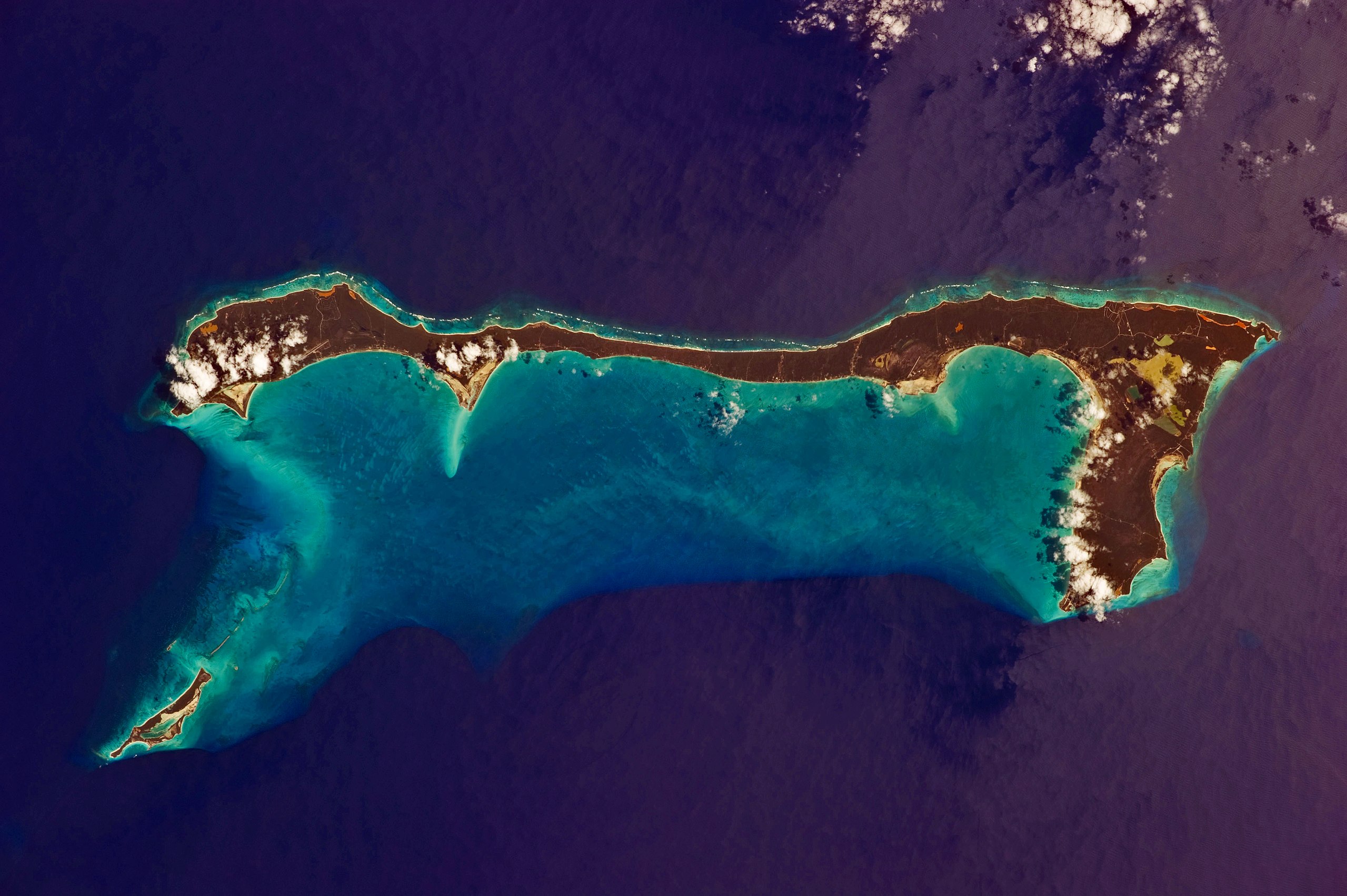
English: Like most other islands in the Bahamas, Cat Island is located on a large depositional platform that is composed mainly of carbonate sediments and surrounding reefs. The approximately 77 kilometre-long island is the part of the platform continuously exposed above water, which allows for soil development (brown to tan areas) and the growth of vegetation.
Shallow water to the west-south-west (below the island in this view) appears bright blue, in contrast to the deeper ocean waters to the north, east, and south. In this astronaut photograph, the ocean surface near the south-eastern half of the island has a slight grey tinge due to sun-glint, or light reflecting off the water surface back towards the International Space Station. Small white cumulus clouds obscure some parts of the island. |
| Date | |
| Source | NASA Earth Observatory |
| Auteur | ISS Expedition 26 crew |
| Lieu de la prise de vue | | Voir cet endroit et d’autres images sur : OpenStreetMap |
|---|
Cette image ou vidéo a été cataloguée par le Johnson Space Center de la National Aeronautics and Space Administration (NASA) des États-Unis sous Photo ID : ISS026-E-33193.Ce bandeau n’indique rien sur le statut de l’œuvre au regard du droit d'auteur. Un bandeau de droit d’auteur est requis. Voir Commons:À propos des licences pour plus d’informations. Autres langues :
|
Image acquired with a Nikon D3S digital camera using an effective 135 mm lens, and is provided by the ISS Crew Earth Observations experiment and Image Science & Analysis Laboratory, Johnson Space Center.
Conditions d’utilisation
| Ce fichier provient de la NASA. Sauf exception, les documents créés par la NASA ne sont pas soumis à copyright. Pour plus d'informations, voir la politique de copyright de la NASA. | ||
 |
Attention :
|
| Annotations | Cette image est annotée : Voir les annotations sur Wikimedia Commons |
Historique du fichier
Cliquer sur une date et heure pour voir le fichier tel qu'il était à ce moment-là.
| Date et heure | Vignette | Dimensions | Utilisateur | Commentaire | |
|---|---|---|---|---|---|
| actuel | 21 mars 2011 à 12:37 | | 4 256 × 2 832 (6,61 Mio) | Originalwana | {{Information |Description ={{en|1=Like most other islands in the Bahamas, Cat Island is located on a large depositional platform that is composed mainly of carbonate sediments and surrounding reefs. The approximately 77 kilometre-long island is the pa |
Utilisation du fichier
La page suivante utilise ce fichier :
Usage global du fichier
Les autres wikis suivants utilisent ce fichier :
- Utilisation sur ar.wikipedia.org
- Utilisation sur arz.wikipedia.org
- Utilisation sur az.wikipedia.org
- Utilisation sur ca.wikipedia.org
- Utilisation sur ceb.wikipedia.org
- Utilisation sur cs.wikipedia.org
- Utilisation sur de.wikipedia.org
- Utilisation sur de.wikivoyage.org
- Utilisation sur el.wikipedia.org
- Utilisation sur en.wikipedia.org
- Utilisation sur es.wikipedia.org
- Utilisation sur fi.wikipedia.org
- Utilisation sur he.wikipedia.org
- Utilisation sur it.wikipedia.org
- Utilisation sur ko.wikipedia.org
- Utilisation sur lt.wikipedia.org
- Utilisation sur nl.wikipedia.org
- Utilisation sur no.wikipedia.org
- Utilisation sur pl.wikipedia.org
- Utilisation sur pt.wikipedia.org
- Utilisation sur ro.wikipedia.org
- Utilisation sur www.wikidata.org
- Utilisation sur zh.wikipedia.org