Fichier:CampañaRumanaSeptiembreNoviembre1916Enero1917.svg

Taille de cet aperçu PNG pour ce fichier SVG : 783 × 600 pixels. Autres résolutions : 313 × 240 pixels | 627 × 480 pixels | 1 003 × 768 pixels | 1 280 × 980 pixels | 2 560 × 1 961 pixels | 2 538 × 1 944 pixels.
Fichier d’origine (Fichier SVG, nominalement de 2 538 × 1 944 pixels, taille : 1,33 Mio)
Ce fichier et sa description proviennent de Wikimedia Commons.
| Description |
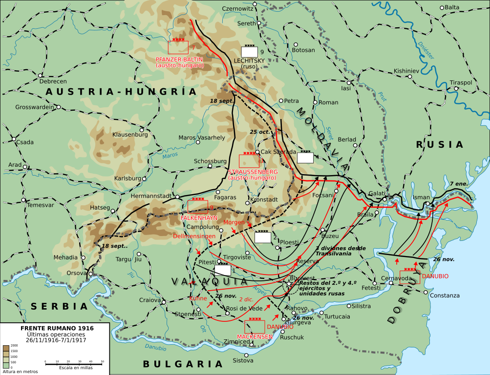
English: This map shows the conquest of Romania: November 1916 through till January of 1917
This map was created by the Department of Military Art and Engineering, at the U.S. Military Academy (West Point). The initial version was created under the supervision of General Vincent Esposito in 1959. It is now available on the West Point web site at: http://www.dean.usma.edu/history/web03/atlases/great%20war/great%20war%20%20pages/great%20war%20map%2037.htm
Español: Últimas operaciones de la campaña rumana de 1916: la retirada a Moldavia y la toma por los Imperios Centrales de Dobruja y Valaquia. |
||
| Date | (UTC) | ||
| Source | |||
| Auteur |
|

| Cette image a été retouchée, ce qui signifie qu'elle a été modifiée par ordinateur et est différente de l'image d'origine. Liste des modifications : turned into svg and Spanish. L'image d'origine se trouve ici : Romania-WW1-3.jpg:
|
Ce fichier est disponible selon les termes de la licence Creative Commons Attribution – Partage dans les Mêmes Conditions 3.0 (non transposée).
- Vous êtes libre :
- de partager – de copier, distribuer et transmettre cette œuvre
- d’adapter – de modifier cette œuvre
- Sous les conditions suivantes :
- paternité – Vous devez donner les informations appropriées concernant l'auteur, fournir un lien vers la licence et indiquer si des modifications ont été faites. Vous pouvez faire cela par tout moyen raisonnable, mais en aucune façon suggérant que l’auteur vous soutient ou approuve l’utilisation que vous en faites.
- partage à l’identique – Si vous modifiez, transformez, ou vous basez sur cette œuvre, vous devez distribuer votre contribution sous la même licence ou une licence compatible avec celle de l’original.
Journal des téléversements d’origine
This image is a derivative work of the following images:
- File:Romania-WW1-3.jpg licensed with PD-USGov
- 2006-12-28T16:42:16Z Electionworld 1018x868 (162492 Bytes) {{ew|en|Cglassey}} == Summary == This map shows the conquest of Romania: November 1916 through till January of 1917 This map was created by the Department of Military Art and Engineering, at the U.S. Military Academy (West P
Téléversé avec derivativeFX
Historique du fichier
Cliquer sur une date et heure pour voir le fichier tel qu'il était à ce moment-là.
| Date et heure | Vignette | Dimensions | Utilisateur | Commentaire | |
|---|---|---|---|---|---|
| actuel | 8 octobre 2017 à 00:01 | | 2 538 × 1 944 (1,33 Mio) | Rowanwindwhistler | Size |
| 7 octobre 2017 à 23:51 |  | 2 553 × 2 000 (1,29 Mio) | Rowanwindwhistler | Region names, river names, Jiu river, legend... | |
| 22 janvier 2017 à 11:03 |  | 1 284 × 983 (1,05 Mio) | Rowanwindwhistler | Some minor errors corrected. Fake text added. | |
| 4 février 2016 à 08:12 |  | 1 204 × 922 (474 kio) | Rowanwindwhistler | Some text moved for better readability | |
| 4 février 2016 à 08:05 |  | 1 204 × 922 (474 kio) | Rowanwindwhistler | Minor corrections, some colours & symbols from https://en.wikipedia.org/wiki/Wikipedia:WikiProject_Maps/Conventions | |
| 8 septembre 2010 à 17:36 |  | 1 242 × 961 (464 kio) | Rowanwindwhistler | Wrong unit deleted | |
| 8 septembre 2010 à 17:33 |  | 1 242 × 961 (472 kio) | Rowanwindwhistler | {{Information |Description={{en|1=This map shows the conquest of Romania: November 1916 through till January of 1917 This map was created by the Department of Military Art and Engineering, at the U.S. Military Academy (West Point). The initial version was |
Utilisation du fichier
Les 7 pages suivantes utilisent ce fichier :
Usage global du fichier
Les autres wikis suivants utilisent ce fichier :
- Utilisation sur ca.wikipedia.org
- Utilisation sur es.wikipedia.org
- Utilisation sur sh.wikipedia.org
- Utilisation sur uk.wikipedia.org