Fichier:Butler Chapel African Methodist Episcopal Zion Church.JPG

Taille de cet aperçu : 800 × 580 pixels. Autres résolutions : 320 × 232 pixels | 640 × 464 pixels | 1 024 × 742 pixels | 1 280 × 928 pixels | 2 560 × 1 856 pixels | 3 381 × 2 451 pixels.
Fichier d’origine (3 381 × 2 451 pixels, taille du fichier : 1,84 Mio, type MIME : image/jpeg)
Ce fichier et sa description proviennent de Wikimedia Commons.
|
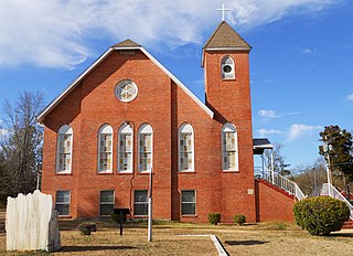
Ceci est une photographie d’un monument référencé dans le National Register of Historic Places des États-Unis sous le numéro 95001022. |
Description
| Description |
English: This is a photograph of Butler Chapel African Methodist Episcopal Zion Church located in Tuskegee, Alabama.
"This church was the focal point for a multi-year grass-roots project that united and empowered African Americans, rural and urban, educated and uneducated, to fight for the right to vote. Butler Chapel AME Zion Church, an imposing brick building located on a hill west of downtown Tuskegee, is a prominent landmark in the historically black neighborhood known as Zion Hill. The building, the second church on this site, was constructed about 1877. Originally built in wood, the church was sided with brick in the 1940s. In a 1957 effort to minimize the number of black voters in Tuskegee, Alabama's municipal elections, the state legislature simply redrew the town's political districts, placing Tuskegee Institute and all but a small fraction of black residents outside city limits. To protest this action, Tuskegee's middle-class black community and Macon County's poor black citizens joined forces in a seven-year "Crusade for Citizenship." On June 25, 1957, 3,000 area black residents showed up at Butler Chapel for the first of many weekly mass meetings. Only 500 attendees could fit into the church's small sanctuary; the rest listened outside. Charles Gomillion, a professor at Tuskegee Institute and the driving force of the black Tuskegee Civic Association, urged the crowd to join a "Trade with Friends" boycott of local white merchants. "We are going to buy goods and services from those who help us, from those who make no effort to hinder us, from those who recognize us as first-class citizens," he promised. The boycott ended in early 1961 when city boundaries were returned to their original position, after the Supreme Court ruled that a legislature could not single out an isolated segment of a racial minority for discriminatory treatment." [Source: NPS.gov] |
||
| Date | |||
| Source | ME Travail personnel | ||
| Auteur | Rivers A. Langley; SaveRivers | ||
| Autorisation (Réutilisation de ce fichier) |
Moi, en tant que détenteur des droits d’auteur sur cette œuvre, je la publie sous les licences suivantes : Ce fichier est disponible selon les termes de la licence Creative Commons Attribution – Partage dans les Mêmes Conditions 3.0 (non transposée).
Vous pouvez choisir l’une de ces licences. |

| Position de l'objet | | Voir cet endroit et d’autres images sur : OpenStreetMap |
|---|
Historique du fichier
Cliquer sur une date et heure pour voir le fichier tel qu'il était à ce moment-là.
| Date et heure | Vignette | Dimensions | Utilisateur | Commentaire | |
|---|---|---|---|---|---|
| actuel | 18 février 2011 à 20:39 | | 3 381 × 2 451 (1,84 Mio) | SaveRivers | {{Information |Description ={{en|1=This is a photograph of Butler Chapel African Methodist Episcopal Zion Church located in Tuskegee, Alabama.}} |Source =ME {{own}} |Author =Rivers A. Langley; SaveRivers |Date |
Utilisation du fichier
La page suivante utilise ce fichier :
Usage global du fichier
Les autres wikis suivants utilisent ce fichier :
- Utilisation sur arz.wikipedia.org
- Utilisation sur de.wikipedia.org
- Utilisation sur en.wikipedia.org
- Utilisation sur fa.wikipedia.org
- Utilisation sur hy.wikipedia.org
- Utilisation sur uk.wikipedia.org
- Utilisation sur www.wikidata.org