Fichier:Belgian Railway Line 25.png
Taille de cet aperçu : 800 × 548 pixels. Autres résolutions : 320 × 219 pixels | 640 × 438 pixels | 1 024 × 701 pixels | 1 280 × 877 pixels | 1 546 × 1 059 pixels.
Fichier d’origine (1 546 × 1 059 pixels, taille du fichier : 2,5 Mio, type MIME : image/png)
Ce fichier et sa description proviennent de Wikimedia Commons.
Description
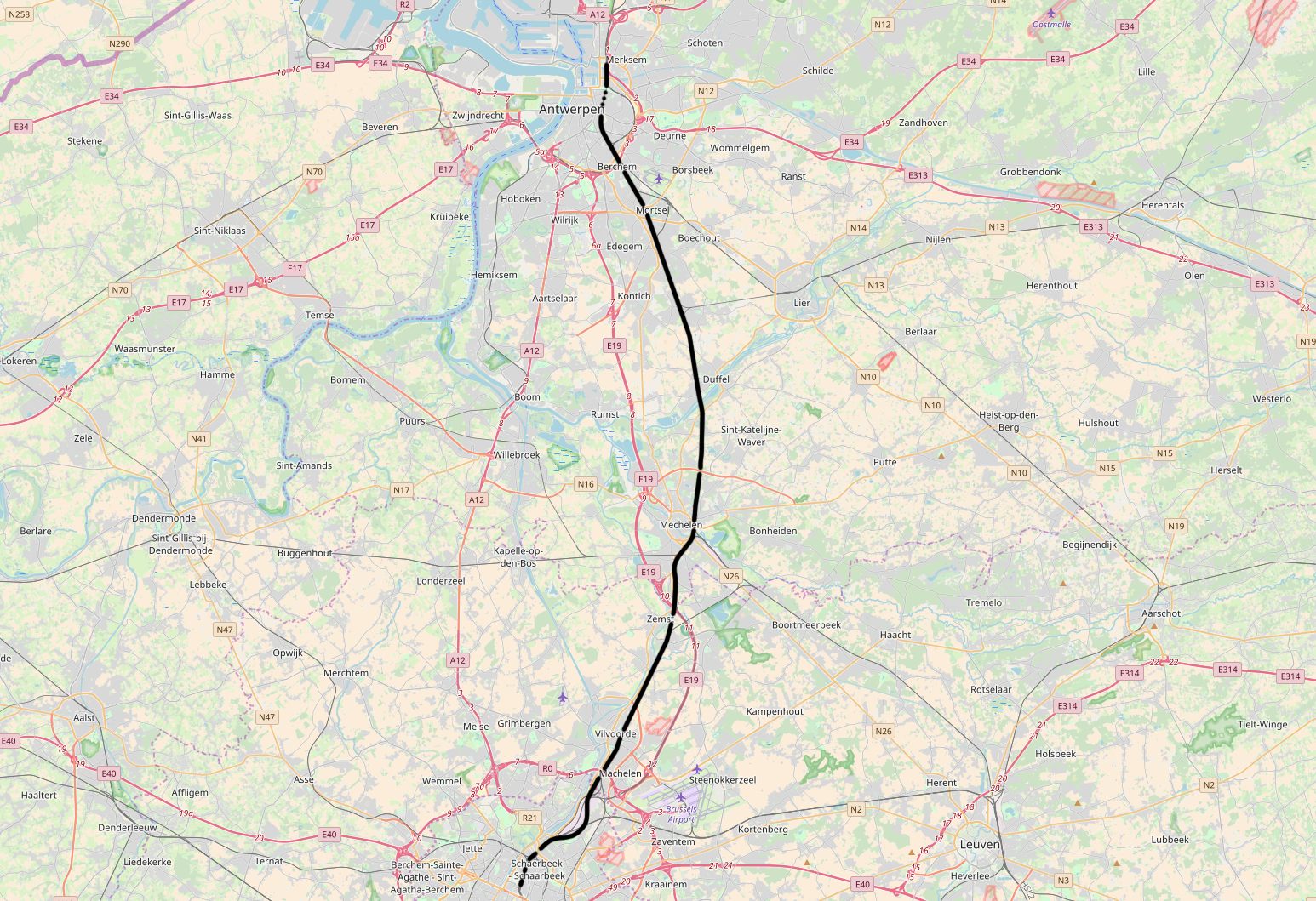
| Description | Belgian Railway Line 25, Brussel-Noord - Antwerpen-Luchtbal |
| Source | openstreetmap.org, see Relation: 57979 from the OpenStreetMap Belgium/Railways project. |
| Auteur | OpenStreetMap contributors |
| Autorisation (Réutilisation de ce fichier) |
All OpenStreetMap data and maps are Creative Commons "CC-BY-SA 2.0" licensed |
Conditions d’utilisation
Ce fichier est disponible selon les termes de la licence Creative Commons Attribution – Partage dans les Mêmes Conditions 2.0 Générique
- Vous êtes libre :
- de partager – de copier, distribuer et transmettre cette œuvre
- d’adapter – de modifier cette œuvre
- Sous les conditions suivantes :
- paternité – Vous devez donner les informations appropriées concernant l'auteur, fournir un lien vers la licence et indiquer si des modifications ont été faites. Vous pouvez faire cela par tout moyen raisonnable, mais en aucune façon suggérant que l’auteur vous soutient ou approuve l’utilisation que vous en faites.
- partage à l’identique – Si vous modifiez, transformez, ou vous basez sur cette œuvre, vous devez distribuer votre contribution sous la même licence ou une licence compatible avec celle de l’original.
Historique du fichier
Cliquer sur une date et heure pour voir le fichier tel qu'il était à ce moment-là.
| Date et heure | Vignette | Dimensions | Utilisateur | Commentaire | |
|---|---|---|---|---|---|
| actuel | 11 novembre 2017 à 13:22 | | 1 546 × 1 059 (2,5 Mio) | Vunz | fix |
| 14 mai 2014 à 11:54 |  | 1 489 × 1 111 (2,85 Mio) | Vunz | improved | |
| 2 septembre 2010 à 17:24 |  | 1 065 × 772 (1,33 Mio) | Vunz | ||
| 26 octobre 2009 à 10:07 |  | 1 065 × 772 (1,33 Mio) | Vunz | Reverted to version as of 13:23, 24 September 2009 - Expanded much better, former lines not correct | |
| 18 octobre 2009 à 14:49 |  | 520 × 390 (41 kio) | Wester | Kaartje is ten eerste te druk voor de infobox, ten twede staan de voormalige spoorlijnen er niet op. | |
| 24 septembre 2009 à 15:23 |  | 1 065 × 772 (1,33 Mio) | Vunz | Open Street Map Category:Rail transport maps of Belgium | |
| 4 janvier 2009 à 19:53 |  | 520 × 390 (41 kio) | Vunz | extended to Antwerpen-Luchtbal Category:Public domain maps from demis.nl Category:Rail transport maps of Belgium | |
| 17 mars 2007 à 22:47 |  | 640 × 480 (60 kio) | Arafi | {{Information |Description=Schematische voorstelling van de spoorlijn 25 in België |Source=eigen werk (gebaseerd op http://www.demis.nl/wms/mapclip.htm) |Date=17 maart 2007 |Author='''Rafaël Delaedt''' (Arafi) |Permission={{PD-Demis}} }} |
Utilisation du fichier
La page suivante utilise ce fichier :
Usage global du fichier
Les autres wikis suivants utilisent ce fichier :
- Utilisation sur de.wikipedia.org
- Utilisation sur en.wikipedia.org
- Utilisation sur it.wikipedia.org
- Utilisation sur ko.wikipedia.org
- Utilisation sur nl.wikipedia.org
- Utilisation sur www.wikidata.org
- Utilisation sur zh.wikipedia.org