Fichier:Battle of Mount Sorrel - Battle Map - June 6 (restored1).jpg

Fichier d’origine (1 741 × 2 800 pixels, taille du fichier : 1,94 Mio, type MIME : image/jpeg)
Ce fichier et sa description proviennent de Wikimedia Commons.
| Description |
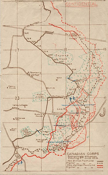
English: This map illustrates the British/Canadian positions (in brown) and the German lines (in red) on 4 June 1916, during the Battle of Mount Sorrel. The Canadians have been driven from several strong points, including Hooge north), Mount Sorrel itself (south), and most of Observatory Ridge (centre). |
|||
| Date | ||||
| Source |
George Metcalf Archival Collection, Canadian War Museum: 19870027-018 [1] |
|||
| Auteur | n.d. | |||
| Autorisation (Réutilisation de ce fichier) |
|
|||
| Autres versions |
 |

.jpg?uselang=fr)
![[1]](http://www.warmuseum.ca/cwm/exhibitions/guerre/photos/2800/19870027-018.jpg)
| Cette image a été retouchée, ce qui signifie qu'elle a été modifiée par ordinateur et est différente de l'image d'origine. Liste des modifications : Tears, holes and major folds & creases repaired or decreased in intensity..
|
| Lieu de la prise de vue | | Voir cet endroit et d’autres images sur : OpenStreetMap |
|---|
.jpg¶ms=050.841342_N_0002.948456_E_globe:Earth_type:camera_scale:10000_region:BE_&language=fr)
Historique du fichier
Cliquer sur une date et heure pour voir le fichier tel qu'il était à ce moment-là.
| Date et heure | Vignette | Dimensions | Utilisateur | Commentaire | |
|---|---|---|---|---|---|
| actuel | 19 décembre 2009 à 23:12 | | 1 741 × 2 800 (1,94 Mio) | Labattblueboy | {{Information |Description={{en|1=This map illustrates the British/Canadian positions (in brown) and the German lines (in red) on 4 June 1916, during the Battle of Mount Sorrel. The Canadians have been driven from several strong points, including Hooge no |
Utilisation du fichier
La page suivante utilise ce fichier :
Usage global du fichier
Les autres wikis suivants utilisent ce fichier :
- Utilisation sur en.wikipedia.org
- Utilisation sur he.wikipedia.org
- Utilisation sur nl.wikipedia.org
- Utilisation sur sk.wikipedia.org
- Utilisation sur www.wikidata.org
.jpg)