Fichier:All Hallows, Clixby - geograph.org.uk - 429150.jpg
Pas de plus haute résolution disponible.
All_Hallows,_Clixby_-_geograph.org.uk_-_429150.jpg (640 × 480 pixels, taille du fichier : 120 kio, type MIME : image/jpeg)
Ce fichier et sa description proviennent de Wikimedia Commons.
Description
| Description |
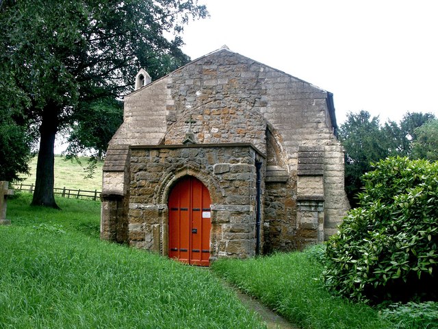
English: All Hallows, Clixby The chancel of the 13th-century church of All Hallows was badly in need of repair until it was restored in 1889 and a west porch was added. In the floor is a 14th-century slab with an incised cross and chalice and the remains of a Lombardic inscription to a priest. Latin inscriptions in praise of the Virgin adorn the wooden ceiling. The carved octagonal font and pews with poppy heads have been rescued from other redundant churches. The altar has a triptych which includes the crucifixion, burial and resurrection of Christ. |
| Date | |
| Source | From geograph.org.uk |
| Auteur | Dave Hitchborne |
| Attribution (imposé par la licence) | Dave Hitchborne / All Hallows, Clixby / |
| Lieu de la prise de vue | | Voir cet endroit et d’autres images sur : OpenStreetMap |
|---|
_heading:90.00&language=fr)
| Position de l'objet | | Voir cet endroit et d’autres images sur : OpenStreetMap |
|---|
_heading:90.00&language=fr)
Conditions d’utilisation

|
Cette image provient de la collection du projet Geograph British Isles. Pour obtenir les coordonnées du photographe, veuillez consulter cette page de description de l'image sur le site du projet. Les droits d'auteurs sur cette image sont détenus par Dave Hitchborne ; l'image est placée sous une licence Creative Commons avec mention de paternité et partage à l'identique (CC-By-SA) en version 2.0.
|
Ce fichier est disponible selon les termes de la licence Creative Commons Attribution – Partage dans les Mêmes Conditions 2.0 Générique
Attribution: Dave Hitchborne
- Vous êtes libre :
- de partager – de copier, distribuer et transmettre cette œuvre
- d’adapter – de modifier cette œuvre
- Sous les conditions suivantes :
- paternité – Vous devez donner les informations appropriées concernant l'auteur, fournir un lien vers la licence et indiquer si des modifications ont été faites. Vous pouvez faire cela par tout moyen raisonnable, mais en aucune façon suggérant que l’auteur vous soutient ou approuve l’utilisation que vous en faites.
- partage à l’identique – Si vous modifiez, transformez, ou vous basez sur cette œuvre, vous devez distribuer votre contribution sous la même licence ou une licence compatible avec celle de l’original.
Historique du fichier
Cliquer sur une date et heure pour voir le fichier tel qu'il était à ce moment-là.
| Date et heure | Vignette | Dimensions | Utilisateur | Commentaire | |
|---|---|---|---|---|---|
| actuel | 4 février 2011 à 05:40 | | 640 × 480 (120 kio) | GeographBot | == {{int:filedesc}} == {{Information |description={{en|1=All Hallows, Clixby The chancel of the 13th-century church of All Hallows was badly in need of repair until it was restored in 1889 and a west porch was added. In the floor is a 14th-century slab wi |
Utilisation du fichier
La page suivante utilise ce fichier :
Usage global du fichier
Les autres wikis suivants utilisent ce fichier :