Fichier:Aerial view of the ruins of medieval flood control Midai river.jpg

Taille de cet aperçu : 800 × 493 pixels. Autres résolutions : 320 × 197 pixels | 640 × 394 pixels | 1 024 × 631 pixels | 1 280 × 789 pixels | 2 560 × 1 577 pixels | 3 567 × 2 198 pixels.
Fichier d’origine (3 567 × 2 198 pixels, taille du fichier : 2,9 Mio, type MIME : image/jpeg)
Ce fichier et sa description proviennent de Wikimedia Commons.
Description
| Description |
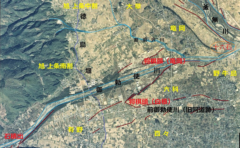
English: Aerial view of the ruins of medieval flood control Midai river.
日本語: 御勅使川、治水土木史跡等の注釈を記入した空中写真。1976年撮影Ccb-76-13_c22b_15を利用。 |
| Date | |
| Source | 国土情報ウェブマッピングシステム |
| Auteur | 国土交通省 |
Conditions d’utilisation

|
Le détenteur des droits d’auteur de ce fichier, Ministère du Territoire, des Infrastructures, des Transports et du Tourisme, autorise n’importe qui à l’utiliser pour n’importe quelle utilisation, pourvu que le détenteur des droits d’auteur soit correctement attribué. La redistribution, les œuvres dérivées, l’utilisation commerciale et toutes les autres utilisations sont autorisées. |
Attribution:
Copyright © National Land Image Information (Color Aerial Photographs), Ministry of Land, Infrastructure, Transport and Tourism
|
 |
This image is copyrighted by the Ministry of Land, Infrastructure, Transport and Tourism of Japan. For terms of use, see the stipulation to use of National Land Information (in Japanese) and message from MLIT (in Japanese and English). When you display this image on an article, include the following phrase in the description: "Made based on National Land Image Information (Color Aerial Photographs), Ministry of Land, Infrastructure, Transport and Tourism".
|
Historique du fichier
Cliquer sur une date et heure pour voir le fichier tel qu'il était à ce moment-là.
| Date et heure | Vignette | Dimensions | Utilisateur | Commentaire | |
|---|---|---|---|---|---|
| actuel | 31 juillet 2013 à 08:41 | | 3 567 × 2 198 (2,9 Mio) | さかおり | {{Information |Description ={{en|1=Aerial view of the ruins of medieval flood control Midai river.}} {{ja|1=御勅使川、治水土木史跡等の注釈を記入した空中写真。1976年撮影Ccb-76-13_c22b_15を利用。}} |Source =国... |
Utilisation du fichier
La page suivante utilise ce fichier :
Usage global du fichier
Les autres wikis suivants utilisent ce fichier :
- Utilisation sur ja.wikipedia.org