Fichier:Adriatic Plate.jpg
Taille de cet aperçu : 626 × 600 pixels. Autres résolutions : 250 × 240 pixels | 501 × 480 pixels | 817 × 783 pixels.
Fichier d’origine (817 × 783 pixels, taille du fichier : 181 kio, type MIME : image/jpeg)
Ce fichier et sa description proviennent de Wikimedia Commons.
Description
| Description |
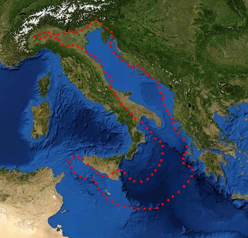
English: boundaries of the Adriatic plate
עברית: גבולות הלוח האדריאטי |
| Date | (UTC) |
| Source |
Mediterranian_Sea_16.61811E_38.99124N.jpg (July 2012). "Present kinematics of Central and Northern Italy from continuous GPS measurements". Journal of Geodynamics 58: 62-72. Elsevier. ISSN 0264-3707. Retrieved on 12 March 2012. plate boundary map preview |
| Auteur |
|
| Cette image a été retouchée, ce qui signifie qu'elle a été modifiée par ordinateur et est différente de l'image d'origine. Liste des modifications : crop, plate boundaries. L'image d'origine se trouve ici : Mediterranian Sea 16.61811E 38.99124N.jpg:
|
Conditions d’utilisation
| Cette image est dans le domaine public car elle est constituée d'une capture d'écran du logiciel World Wind de la NASA qui utilise des données du domaine public, comme Blue Marble, MODIS, Landsat, SRTM, USGS ou GLOBE.
|
 |
| This work was previously under Public Domain, or a Free License. It has been digitally enhanced and/or modified. This derivative work has been (or is hereby) released into the public domain by its author, [[:{{{1}}}:User:{{{3}}}|{{{3}}}]] at the [[:{{{1}}}:|{{{2}}}]] project. This applies worldwide. In some countries this is not legally possible; if so:
|
Journal des téléversements d’origine
This image is a derivative work of the following images:
- File:Mediterranian_Sea_16.61811E_38.99124N.jpg licensed with PD-WorldWind, PD-retouched-user-w
Téléversé avec derivativeFX
Historique du fichier
Cliquer sur une date et heure pour voir le fichier tel qu'il était à ce moment-là.
| Date et heure | Vignette | Dimensions | Utilisateur | Commentaire | |
|---|---|---|---|---|---|
| actuel | 29 décembre 2011 à 19:52 | | 817 × 783 (181 kio) | דקי | == {{int:filedesc}} == {{Information |Description={{en|boundaries of the Adriatic plate}} {{he|גבולות הלוח האדריאטי}} |Source=*File:Mediterranian_Sea_16.61811E_38.99124N.jpg |Date=2011-12-29 17:47 (UTC) |Author=*[[:File:Mediterrani |
Utilisation du fichier
La page suivante utilise ce fichier :
Usage global du fichier
Les autres wikis suivants utilisent ce fichier :
- Utilisation sur az.wikipedia.org
- Utilisation sur bg.wikipedia.org
- Utilisation sur bn.wikipedia.org
- Utilisation sur ca.wikipedia.org
- Utilisation sur cs.wikipedia.org
- Utilisation sur de.wikipedia.org
- Utilisation sur el.wikipedia.org
- Utilisation sur en.wikipedia.org
- Utilisation sur es.wikipedia.org
- Utilisation sur fa.wikipedia.org
- Utilisation sur he.wikipedia.org
- Utilisation sur hr.wikipedia.org
- Utilisation sur hu.wikipedia.org
- Utilisation sur it.wikipedia.org
- Utilisation sur ja.wikipedia.org
- Utilisation sur nl.wikipedia.org
- Utilisation sur pl.wikipedia.org
- Utilisation sur pt.wikipedia.org
- Utilisation sur ru.wikipedia.org
- Utilisation sur sh.wikipedia.org
- Utilisation sur sl.wikipedia.org
- Utilisation sur sv.wikipedia.org
- Utilisation sur tr.wikipedia.org
- Utilisation sur uk.wikipedia.org
- Utilisation sur zh.wikipedia.org