Fichier:1980 St. Helens ashmap.png
Taille de cet aperçu : 800 × 545 pixels. Autres résolutions : 320 × 218 pixels | 640 × 436 pixels | 808 × 550 pixels.
Fichier d’origine (808 × 550 pixels, taille du fichier : 11 kio, type MIME : image/png)
Ce fichier et sa description proviennent de Wikimedia Commons.
Conditions d’utilisation

|
Une version vectorielle de cette image existe, dans le format « SVG ». Elle devrait être utilisée à la place de cette image matricielle.
File:1980 St. Helens ashmap.png → File:1980 Mount st helens ash distribution.svg
Pour plus d’informations sur les images vectorielles, consultez la page de transition de Commons vers le format SVG. Voir aussi les informations à propos de la manière dont le logiciel MediaWiki gère les images au format SVG. |
 |
Cette image est placée dans le domaine public parce qu'elle contient des éléments issus de l'United States Geological Survey, une agence du Département de l'Intérieur des États-Unis. Pour plus d'information, consultez la politique officielle de copyright de l'USGS (en anglais)
|
Historique du fichier
Cliquer sur une date et heure pour voir le fichier tel qu'il était à ce moment-là.
| Date et heure | Vignette | Dimensions | Utilisateur | Commentaire | |
|---|---|---|---|---|---|
| actuel | 25 septembre 2008 à 23:00 | | 808 × 550 (11 kio) | AVRS | optipng -o7 && advpng -z4 |
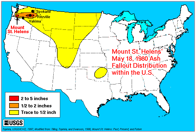
| 30 mars 2006 à 06:01 |  | 808 × 550 (14 kio) | Mnh | Transferred from en:Image:1980_St._Helens_ashmap.png. Map is the work of a USGS employee and thus a work of the US government. Originally uploaded by en:User:Maveric149. Image contents: Ash deposits from the 1980 eruption of Mount St. Helens we |
Utilisation du fichier
La page suivante utilise ce fichier :